
This blog is a Book Blog. The entire blog is about a book titled Retrieve Africa written by me. The book is comprised of nine chapters including the Prologue and the Epilogue.
THE BOOK IS AVAILABLE FOR PURCHASE, ALONG WITH MY OTHER BOOKS, AT
1. LULU PUBLISHING: lulu.com/spotlight/ccnweze - Paperbacks and ebooks
2. OKADA BOOKS: https://okadabooks.com/user/C.C.Nweze - ebooks only
READ, ENJOY, UNDERSTAND, DECIDE

THE BOOK:
--------------------------------------------------------------
Retrieve
Africa
Chukwuma Nweze
Dr
C. C. Nweze
The
True Vine Clinic
184 Agbani Road
Enugu
E-mail: ccnweze@gmail.com
Website: Fountain of Reason
(foutainheadrepository.com)
First Published 2020
All Rights Reserved
No part of this publication
may be reproduced, stored in a retrieval system
or transmitted in any form or by any means, electronic, mechanical,
photographing, recording or otherwise, without the written permission of the
author.
ISBN: 978-1-716-38551-3
Dedication
To all authentic
Africans who are proud of their bona fide African heritage
Prologue
There has been a long reflection on the situation in which I find myself as a Biafran living in a part of Biafraland that is in a country called Nigeria. Ordinarily, there is not supposed to be a problem being part of a large country with a large population and immense potentials. It is, in fact, supposed to be a big advantage in a federation that functions like a true federation, as I demonstrated in one of my earlier books “Biafra Our Default Homeland” and a glimpse of which we saw in Nigeria’s first republic. There are, however, some fundamental issues that could be problematic even in a beautifully crafted federation. These include incompatibility caused by incompatible heritage, especially in culture and traditional mindset.
This explains why there was still a huge problem that led to the intractable crisis in that Nigeria which had a federation arrangement that was economically very beneficial. It turned out this incompatibility caused by irreconcilable differences in culture and traditional mindset was responsible:
When the federation was signed and sealed, Eastern Nigerian part of it brought along their republican, adventurous, progressive nature, their love for Western life and Western education and an aptitude for industry, commerce, community development and communal self-help. The Western part brought with it zeal, organization, creativity, love for Western education, selflessness, superb tradition and culture with constructively-styled monarchy.
The Northern Part brought with it the predominantly “Far North” agenda of an advanced administrative system, zeal for Islamic religion and Islamic education and the relegation of Western education, great energy and productivity of the people in agriculture including a gigantic animal industry, crafts and sundry artisanship, a highly developed monarchical system that predominantly consists of Emirates and run by Emirs as oligarchies that are essentially hegemonic. This hegemony is the source of the mystery water that entered the flute of the pumpkin1.
Soon, this showed up in the attempt of the North to manipulate and dominate other parts, leading to the tragic Middle Belt crisis, the hurricane blood-and-tears Western Nigerian crisis (Operation Wetie) and other political intrigues, all of which became the main reason for the first military coup in 1966, just six years after independence, the civil war the next year and the unending serious problems that have been the lot of Nigeria till today. This is what informed my decision to suggest the retrieval of compatible parts from bad amalgamations into sound federations, in a mode I presented in the book “Biafra Federation”. A chapter in the book is titled “Retrieval” and the introductory text in the chapter, re-presented below, says most of what I have in mind:
Present African countries are artificial creations of the Europeans. Many of the internal conflicts in most of these countries are as a result of the incompatibilities of various parts joined together to form doomed amalgamations called countries.
It also does not make sense to say your country gained Independence from the colonialist country when it is still bearing the name given to it by them. The words of Dr Sukarno, the first president of Indonesia are transcendental truth:
“. . . slaves and dogs are named by their masters. Free men name themselves”2
It is not adequate to accept any kind of country they left behind for us, different from the homeland we had before colonization: many times what was left behind was no more complete and some of our kindred tribes and clans were no more there. Things are worse with such kindred groups joined with incompatible, hostile or unfriendly groups, some of which have strange cultures and mindsets; they have faced resultant insurmountable difficulties over many years.
Some of the colonizing countries also left behind situations that provided avenues through which they continued, furtively, to exercise some control over African countries. This has had, in some instances, unwholesome economic, political and cultural influences on the African countries, and they, most times, do not know what is really wrong with them. The fact is that they are not yet economically, politically and culturally free and self-realized. They are still being controlled through some vestige, innocuous-looking links that are very powerful tools in reality. The solution is for African countries to realize complete independence and take complete control of their nations in every way. We must shake off all shackles of colonialism and make sure that there is none of it left behind
It might not be easy for people to understand the extreme importance of this, but it seems Ahmadu Ahidjo, the former president of Cameroon, did know it, and did feel it deeply, to make him change the colonial name Victoria City of Cameroon to Limbe. So sweet and beautiful was that action that it quickly resonated with the whole world. They now feel something special going to a wonderful city that is really African, and expecting an authentically African sights and sounds, a beauty that is truly African and a traditional African reception, all of which they cannot get in their usual stereotype destinations which have names like a Victoria that is stiff-necked British. The expectation starts with the name and Limbe eventually fulfills their expectations, of a very enriching African experience.
Why would anyone want to retain a European identity for an African reality
Hon. Justice R. N. Onuorah told an important story
in his Foreword to the book Ogwugwu
Ntegbe: “Glanville William (African American), in his book ‘The Destruction
of Black Civilization’, gave an account of a traveler who encountered a lonely
child roaming a desolate area. The traveler confronted the lonely child with a
question why he was walking aimlessly about the area. The child answered him
that all his people who inhabited that area died. The traveler was dumbfounded
and before he could utter another word the lonely child told him that his
people had died because they forgot their history. The traveler went blank and
before he could recover, the lonely child disappeared”.
They
died because they forgot their history!
There is a large wave of identity consciousness going on across the globe, with peoples desiring and pursuing self-determination in various forms. In many countries and regions, the interest is in tracing their bona fide identities and adopting same as the defaults. These exercises have so far resulted in very positive effects in terms of the energy engendered by such realizations and the pride in such realized lofty identities that make them work very hard in line with the greatness they would want their beloved homeland to have in its realized real and cherished identity
This has happened with some countries and they
replaced the names given to them by the colonialists with names from their bona
fide homeland identities. Some of the
countries adopted the names of their bona fide homelands that existed in their
present locations and a few others, replaced their colonial names with the
names of their bona fide homelands from where they migrated to their present
locations3.
--------------------------
Name is important but even more important is
obliterating Europe's arbitrary
post-colonial borders which left Africans carved into countries that did not
represent their heritage and retracing the natural boundaries of indigenous
African nations or their pre-colonial groupings, thereby retracing a semblance
of the original African structure and the associated requisite character. This
African character existed before the intrusion of perverted and perverting
civilizations eroded into it, making it possible for Africans to become
complicit in a shameful slave trade, lured by the strangely alluring materials
the immoral Europeans brought along, including money in hard currency and some
novel bewitching gift items. Then came the final stroke of colonialization
which completely distorted the structure, as well as the already eroded
character, of Africa. We need to retrieve Africa. We need to retrieve peace,
progress and prosperity in Africa.
Contents
*Prologue
1. Original African Concept of Country
2. European Interpretations
3. Cognate and Contiguous Compatibles
4. Balkanization and Colonization
5. Current Absurdities, Consequent Maladies
6. Retrieving Africa
7. Real African Countries in a Post-Retrieval Africa
*Epilugue
Original
African Concept of Country
It is, perhaps, safe to say that the concept of
“country”, as we know it today, is un-African. It is largely European as it can
be seen that it is in Europe and those parts of the world where they had big
influence that such concepts are developed. If North America had been colonized
by as many European countries as colonized Africa, it would have been
balkanized into many smaller countries. Consequently, the United States of
America emerged from colonization as one “country” with boundaries as defined
by the colonialists but retaining its original nature of being a large area
naturally consisting of many nations.
This is also the original nature of Africa – a large area consisting of
many nations.
Africa is no more a large area consisting of many nations
but a large area balkanized into colonies of various European nations and which
has become a large area consisting of independent quasi-countries as
distinguished from true countries meeting the true definition of “country”. The
true definition of “country” is, as in WordWeb, “A politically organized body
of people under a single government”. A country is politically organized. This
means that it is a political entity in which people of similar political and
cultural inclinations agree to belong, which they agree to promote and build
politically, economically, socially and culturally, as well as in other
necessary aspects. The people own the country and are responsible for choosing
the people to serve them as political public servants who are political office
holders.
Practically all the present African countries became
countries as a result of balkanization of Africa by Europe following the Berlin
Conference of 1884-1885. To balkanize means to “divide a territory into small,
hostile states” – WordWeb. This was the situation with Africa where the people
were forced into artificially carved out territories and became citizens of
various “countries” which were governed by other people as colonies and still
retaining, after independence, what they were forced to become, and are, in
most cases, still sharing citizenship with people with whom they do not share
similar political and cultural inclinations.
It is true that the “hostile states” in the
definition of “balkanize” above does not very exactly apply to some of the
African countries but there are in existence, interstate “ward-off” barriers in
the form of rigid country boundaries which present situations akin to
interstate hostility by virtue of the profound difficulty in crossing these boundaries
to enter neighbouring African countries, for whatever business, even to visit
kit and kin separated from them by the
artificial boundaries of the balkanizers. Of course, it is interstate hostility
when relatives cannot freely visit each other because they were made to become
citizens of different countries. The true interstate hostility actually existed
immediately after the balkanization and colonization between the European
colonizers who were ready to do whatever it would take to protect the territories
they grabbed, from the other territory grabbers of Europe, for their benefits.
The original African concept of country is not as we
have it now in Africa, which is what the Europeans presented as their own
concept of country and forced it on Africa. This is what Africa has retained as
its own concept of country. The original African concept of country can be
correctly described as nationhood – the state of being a nation. As has already
been stated Africa is a large area consisting of many nations. These are true
nations and not like those contraptions that are designated as nation and fit
the designation only in idealism rather than in reality.
Many of the African true nations are small enclaves
but had strong governments and respected leaders. The relationships between the
nations were largely cordial and progressive. Exchange of resources, labour and
expertise happened freely as the people moved freely from one kingdom to the
other.
It has been noted in the Epilogue of the book
Biafra Federation, as follows: “The songs and stories
that survived through the generations show that our people had freely
travelled, in the 19th century, from these northern parts of this westernmost
part of Biafra to the coastal parts and beyond, without requiring documentations.
It seems problems only came when they became part of a Nigeria that was created
in the 20th century (1914).
One of these stories created
another symbolism in my hometown, Ogugu in Awgu Local Government Area of Enugu
State, in the northern part of West Biafra. It is the symbolism of Jor-jor
n’Ubanyi (Jaja of Ubani). The imagery is that of “super power, supreme
authority, some impunity and enigma”. Growing up, I often heard the parent
saying to the child, “so you think you are now a Jor-jor n’Ubanyi and your word
is law?” or people complaining and gossiping about someone saying he behaved
like he was now the high and mighty Jor-jor n’Ubanyi.
This Jor-jor n’Ubanyi symbolism,
evidently, put a date to these surviving stories and imageries developed when
our people travelled freely all over the Biafra Empire, as that time when Jaja
was still leader at Bonny (known as Ubani). That was before Jaja created the
Opobo Kingdom in 1869 out of Ubani (Bonny), and becoming King Jaja of
Opobo in 1870. The period in question was, therefore, long before the Berlin
conference of 1884-1885, before balkanization and colonization. It means,
therefore, that Biafra was, hitherto, one big free homeland from the east coast
of the River Niger, through Cameroon, Equatorial Guinea and Gabon”.
Africa seems to have been one undivided area before the arrival of the Europeans, Africans interacting very widely unhindered by any demarcations between peoples.
However, there seemed to be various areas of special
influence of various groups, mostly consisting of multiple numbers of
compatible and congruous, autochthonous nations. These “areas of influence” are
akin to “Federations” as defined in the present age and similar in content to
some modern concepts of “Country”. A number of them were recognized as kingdoms
and empires.
These areas of influence were noticed by early
European travelers and cartographers and the 1644 map of Africa by Willem
Janszoon Blaeu, 1571-1638, best reflects the situation. This map is available
in the Princeton University Library, New Jersey USA. A beautiful map of Africa
with fine engraving and colouring, described as “one of the most decorative and
popular of all early maps of Africa, from the ‘golden age’ of Dutch mapmaking”.
It
shows the borders and the geographical relationships of the various
empires. Biafra Empire was bordered in
the west by Benin Empire, in the North-West by Zanfara Empire, in the North by
Nubia Empire, in the South by Congo and in the East by a group of small nations
in Central Africa. These territorial boundaries in Blaeu’s map cannot be regarded as the so-called
“Europe’s arbitrary borders”, although made by a European, because Blaeu was
merely showing the mapping of observed areas of special influence or
territories of indigenous African governments at that time and not the
boundaries imposed from outside Africa. It can easily be regarded as Africa’s
ancient indigenous borders – the real borders – which did not prevent a
virtually seamless interaction and cooperation in the continent.
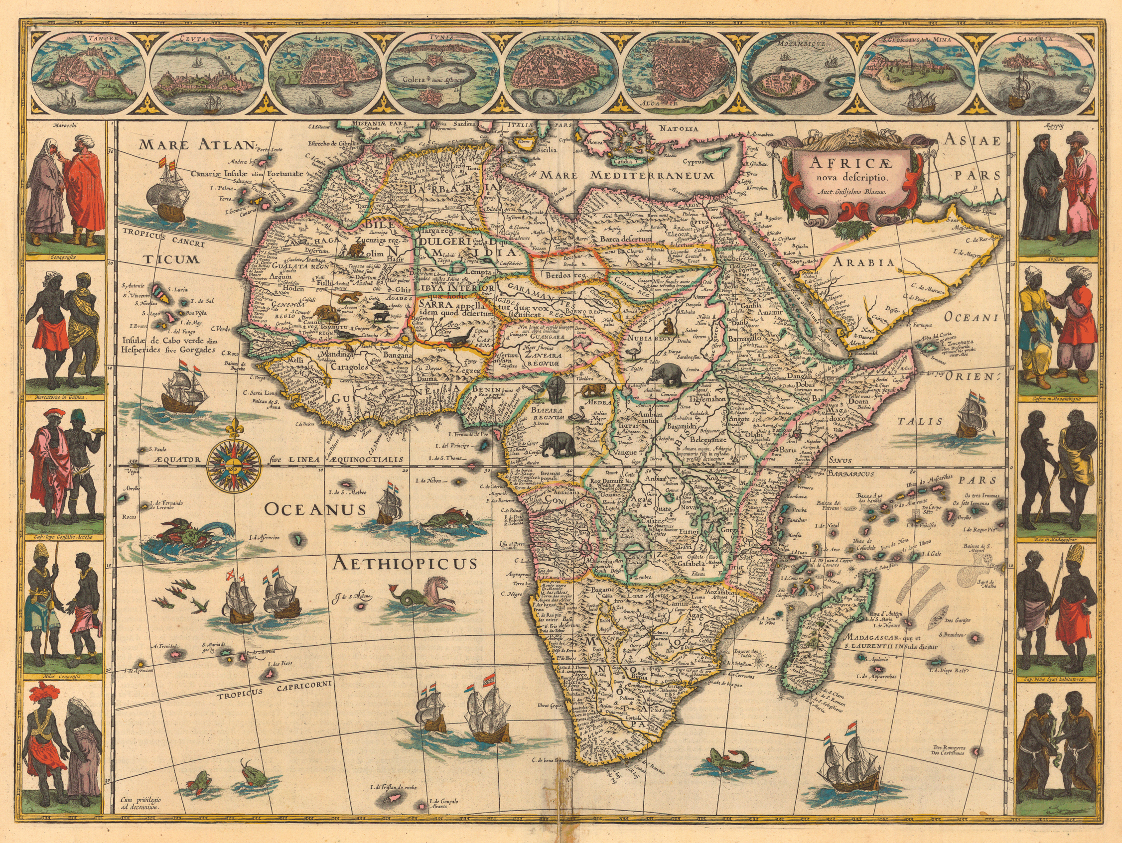
It is clear that in the original African concept of country, there is no “country” as we know today, Africa being made up of nations that did not have border restrictions, but interacted freely with each other, making it look like Africa was one huge un-demarcated territory. Some large areas of special influence were called kingdoms or empires but such designations did not represent strict monarchical domains that have all the people in the said area under the direct control of one king or emperor. It was rather like a system of protectorates to which individual nations subscribed as federating units or as vassals, similar to a feudal system. Each nation in the area had a king who had direct control in the nation. They had various appellations such as Eze, Oba, Amayanabo, Obong and the like.
On the 1644 map of Africa, Princeton University Library comments as follows: “Probably the most important cartographic feature is the identification of specific large areas or kingdoms, which have been outlined in colour, including a huge Abyssinia (Ethiopia) and Monomotapa (all of Southern Africa). But these seem to reflect a European sense of nationhood – something presumed and projected upon a virtually unexplored canvas – more than the actual experience of traders and explorers, who would continue to report on hundreds of smaller enclaves and political fiefdoms during the next 50 years.”4
A closer look could reveal how each of
the delineated enclaves can contain present day countries that can together
become a great federation of compatible nations, each federation presenting
great potentials for being a formidable economic power bloc that is peaceful,
progressive and prosperous, obliterating the present difficulties occasioned by
the uninformed merging of incompatible groups and excision of groups from their
kinsfolks in the process of forming countries according to European
interpretations.
2.
European
Interpretations
When European explorers and travelers got to Africa
they probably looked for evidence of countries and found none. The reports of
the explorers and travelers helped cartographers, along with their own
experiences, to document the territorial situations in Africa at that time.
They made important documentations. There are historical maps that show early
documentations of existence of civilizations organized into various homelands
One of them is this map of Africa done in the last
quarter of the sixteenth century by Abraham Ortelius (1527-1598) who lived and
died in Antwerp in Northern Belgium, where he had a bookselling business. This
map shows small individual African nations dotted all over Africa, without any
territorial demarcations, making the map of Africa look like one homogenous
huge country with nothing of a semblance of countries as we know them today.
 |
1584 map Ortelius, Abraham, “Africae tabula noua.” From Ortelius’s Theatrum orbis terrarum Antwerp, 1584, [Historic Maps Collection: https://libweb5.princeton.edu/visual_materials/maps/websites/africa/maps-continent/1584ortelius.jpg
SOURCE: Princeton University Library |

Down the centuries, the Europeans continued looking for “countries” and found none, but not far from the date of Abraham Ortelius’ map, the Dutch cartographer, Willem Janszoon Blaeu, came up with a description of the reality discussed above in the light of the European reality in a 1644 map that has been described by Princeton University Library as depicting European idea of country4. As already noted, the map depicted Blaeu’s observed areas of special influence or territories of indigenous African governments which contained autonomous nations. He used this experience to map out enclaves with rigid boundaries instead of diffuse associations, which was the reality, in conformity with European interpretations.
Although the rigidness of the boundaries cannot be considered an accurate depiction it seems to be reasonably accurate with regard to mapping out areas of cognate citizenry. Europeans could easily call those demarcated enclaves “countries” but the Dutchman did not do so but regarded them as “kingdoms”, which is a description closest to reality at the time. This central zoom of that Willem Janszoon Blaeu’s 1644 map shows the details:

Some
of those enclaves were real kingdoms but many can be called empires with no
known emperors. An example of the later is Biafra which consisted of nations
that were kingdoms and were part of the empire which history seems to have no
record of its emperor but a record of powerful kings in the constituent nations
that were kingdoms. Biafra Empire, sometimes referred to as kingdom, seems to
have had the trappings of a federation where the constituent nations were
autonomous federating units akin to modern true federations. An example of a
true kingdom in Bleau’s map is Biafra’s neighbour Benin Kingdom which was an
expanded kingdom of the Benin nation to include successively contiguous nations
that became subject to it.
European
interpretations were also seen in several other maps down the centuries:
1710: Herman Moll
A German, Herman Moll (1654-1732) who lived
most of his life in London where he established a book and map store, made his
maps by studying the works of other cartographers. His colorful map shows solid
boundaries that depicted individual countries but these carved-out areas which
he presented as countries, in line with European interpretations of “country”,
also contains named nations or kingdoms within them which were the sovereign
states recognized by African designation:

1710 map Moll, Herman, d. 1732. “To the Right Honourable
Charles, Earl of Peterborow and Monmouth, &c.” [Historic Maps Collection]: https://libweb5.princeton.edu/visual_materials/maps/websites/africa/maps-continent/1710%20moll.jpg
Central Zoom:

SOURCE: Princeton University Library
1841: Samuel G.
Goodrich

Africa. By Samuel G. Goodrich, George W. Boynton, and
Charles D. Strong. From General Atlas of the World. no.
49, http://archive.lib.msu.edu/maps/MSU-Scanned/Africa/300-a-1841-300.jpg
Central Zoom:

SOURCE: Michigan
State University Map Library
1867: Mitchell’s
School Atlas

1866, Africa, from Mitchell's School Atlas "Map of Africa" in Mitchell's school atlas : Philadelphia: E.H.Butler and Co.,1866, c1865. http://img.lib.msu.edu/branches/map/AfJPEGs/30_g1019m67_1867_l.jpg
Central Zoom:

SOURCE: Michigan State University Map Library

1880: Eugène
Andriveau-Goujon

1880 Map. Andriveau-Goujon, E. (Eugène), 1832-1897. “Carte
générale de l’Afrique, d’après les dernières découvertes…” https://libweb5.princeton.edu/visual_materials/maps/websites/africa/maps-continent/1880%20andriveau.jpg
Central
Zoom:

SOURCE: Princeton
University Library
There
are, also, maps of Africa made by Europeans which show there was difficulty for
them to find “countries” in Africa which meet the European idea of “country”.
Attempts could be seen that did not go far enough:
1737: Johann
Matthias Hase

1737 map Hase, Johann Matthias, “Africa secundum legitimas .
. .” https://libweb5.princeton.edu/visual_materials/maps/websites/africa/maps-continent/1737%20hase.jpg
Johann Matthias Hase (1684-1742) was a German mathematician, astronomer and cartographer. He identified important kingdoms and territories in colour and dotted lines but his attempt to delineate territories and kingdoms did not go far enough in defining countries. He did not go further to create map structures to define what did not exist.
1805: John Cary

1805 map Cary, John, ca. 1754-1835. “A New Map of Africa
from the Latest Authorities.” From Cary’s New Universal Atlas (London,
1808). https://libweb5.princeton.edu/visual_materials/maps/websites/africa/maps-continent/1805%20cary.jpg
1874: Ormando
Willis Gray

1874 Map,
Africa. Gray, Ormando Willis. David Rumsey Historical Map Collection.
Philadelphia. Gray's Atlas Map of Africa, https://www.davidrumsey.com/luna/servlet/workspace/handleMediaPlayer?lunaMediaId=RUMSEY~8~1~206913~3003061
In some other maps, the European map makers just reported, with their maps, exactly what they saw and they made correct interpretations because they were not fixated on finding and mapping what they could regard as European-style countries. Their maps rather presented Africa as a big uncharted territory without sovereignties of significant size, such as countries and their governments represented in Europe. Some of these maps are the 1804 Map of Africa, found in Compendious Geographical Dictionary at the Michigan State University Library, Cooper’s Map of Africa published in London by R. Phillips in 1810 and Africa and Cape Colony Map published by Gall and Inglis in 1871, in The Philatelic Database:
1804

1804, Map. Africa. Compendious Geographical Dictionary. Michigan State University Library. http://archive.lib.msu.edu/maps/MSU-Scanned/Africa/300-A-1804Compendious.jpg
1810

Africa. By Cooper. Published in London by R. Phillips in 1810. Michigan State University Library. http://archive.lib.msu.edu/maps/MSU-Scanned/Africa/300-A-1810Phillips.jpg
1871

Africa and Cape
Colony Map (Gall and Inglis 1871). The Philatelic Database: http://www.philatelicdatabase.com/africa/africa-and-cape-colony-map-gall-and-inglis-1871/
This
notion of Africa being an uncharted territory without sovereignties of
significant size is, probably, what gave the Europeans the impression that
territories could be easily grabbed in Africa without much resistance and the
audacity to start scrambling for Africa, leading up to balkanization and
colonization. An 1890 Map in The
Philatelic Database
lends credence to this thought:
1890

1890 Map. The Philatelic Database.
http://www.philatelicdatabase.com/wp-content/uploads/2008/05/africa-map-1890.jpg
Central Zoom:

SOURCE: The Philatelic Database (www.philatelicdatabase.com/
This map was made when the scramble for Africa had
begun and balkanization was already underway and 5 years after the Berlin
Conference. It can be seen that some
areas were designated “unexplored” while some others were marked as belonging
to the European countries that grabbed them.
After the scramble, the balkanization, the Berlin Conference and the
final arrangements including ceding of territories, Africa became a continent
with countries satisfying the European interpretations:

Source: Originalpeople.org http://originalpeople.org/berlin-conference-1884-85/
By 1897 Africa was already partitioned out for European countries: Belgium, Britain, France, Germany, Italy Portugal, and Spain. This is complete destruction of Africa. This strange and complex order brought by the Europeans is the source of the present difficulties and disorder in Africa because it was done selfishly and without regard to nationality, tradition culture, religion and other peculiarities and differences that could determine the criteria for merging excluding or including parts.
How desirable is that European idea of “country” and
how workable is it? This is essentially bringing parts together, rather
indiscriminately to form a union without questions on the compatibility of the
parts, in terms of their cultural heritage, tradition and customary mindsets.
The fact is that this European idea of “country” has
not worked for even Europe as break-up of countries into more compatible parts
has happened in Europe much more than in other parts of the world. Map of
Europe in 1815 has much less number of countries than Europe of the present and
the reasons are well-known history.
The most significant is the “Balkanization of the
Balkans”.

Europe in 1815

Europe in 2015
That European system of “Country and Government” was largely tantamount to an arbitrary creation of un-negotiated and non-negotiable unions and forcing a type of government on them. Contrast this with the United States of America where the union was negotiated and has been continually open to negotiation. The European system was also bestowed ignorantly on Africa as they did not understand the beauty and sublimity of the African system they supplanted.
Africans
were communicating and cooperating harmoniously in the natural space available
to them, where they loved and understood each other no matter how expansive
that available space for interaction and influence was. That is because their
spheres of influence and interaction were not determined by rigid hostile and
exclusive demarcations as in European-imposed “countries” but by their being
non-space-limited cognate and contiguous compatibles.
3.
Cognate
Contiguous Compatibles
Africans are community people, people of kinship,
civic and non-restrictive. They are not strictly nuclear centered, private and
exclusive as is the predominant culture in Europe where the term “extended
family” is not generally well-understood. Large areas in Africa, therefore,
turn out to conform to expansions of various sizes as a result of growth of
families through generations with the branches still linking up and not
migrating too far away. It is, therefore, difficult to place a rigid boundary
on any part of Africa without having to cut a kindred into parts.
Wide areas in Africa are comprised of families and
communities that are culturally and traditionally compatible and have similar
mindsets, deriving from heritage. These cognate entities aggregate to form
nations which interact and cooperate with each other in commerce, industry,
cultural affairs and other spheres. These nations were usually the largest
autonomous governments in place.
In some areas the nations together form larger
unions which early Europeans called empires. Such aggregates of nations were,
sometimes, also referred to as kingdoms regardless of the fact that some of the
component nations have their own kings. These would, therefore, be effectively
regarded as kingdoms within kingdoms. These unions of nations were formed
possibly because of compelling needs and facilitated by their being contiguous
although not sharing heritage.
An example of this is Biafra Empire which was
comprised of nations that were entirely of cognate entities existing in harmony
and freely cooperating with other nations in the empire which have different
heritage. The compatibility seen, which seems to be occasioned by the fact that
being contiguous enabled each of the nations to easily study and understand its
neighbours and ascertain that they had acceptable mindsets and values. The
Igbos, the Efiks, the Ibibios, the Ogonis, the Ekois, the Kalabari people and
other nations in West Biafra were totally integrated and freely interacting
beneficially with each other and with other nations in other parts of the
Biafra Empire now occupied by present day Cameroon, Equatorial Guinea and Gabon
their differences in heritage notwithstanding.
Contiguous nations were sometimes brought together into an empire by conquest and were vassals to the conquering kingdom nation under which name they are governed. They belonged to the same empire regardless of whether they were cognate nations (such as Yoruba nations) or nations of different heritage (such as Bendel nations). Yoruba and Bendel nations formed the Benin Empire which stretched from the west bank of the north-south part of the River Niger to Ketu, formally Dahomy and now Benin Republic, a name chosen by their leaders in recognition of it’s being part of that Benin Empire in the past.
Some of the territories are very vast areas that
were entirely occupied by people that share the same heritage. Abissinia in the
North-East (now present day Ethiopia, part of Central African Republic and part
of Somalia) and Monomotapia in the South (now South Africa, Lesotho, Namibia,
Zimbabwe Botswana, Swaziland, Mozambique, Malawi, part of Angola and part of
Zambia) are good examples. These vast territories seem to be home to entirely
cognate entities and were so homogeneous that some of such areas spoke the same
language. For instance Swahili is still spoken in these present countries that
make up the area that was Monomotapia and even up to East Africa. This is an
indication that entities constituting these African territories share the same
identity and should not have been broken into these present day European-style
countries that are rigidly demarcated and estranged from each other.
Whether these African territories comprised cognate
nations that were compatible on account of being so or were made up of nations
with different backgrounds, compatible by virtue of being contiguous and easily
ascertained to be worthy neighbours with beneficial potentials and freely
accessible homelands, the fact remains that these territories were huge enclaves
of free access and free interaction that freely exploited the potentials and
mutual benefits of the entities.
It may be beneficial to recall my thoughts in the
epilogue of the book “Biafra Federation”, as recorded earlier in this book
under the chapter “Original African Concept of Country”, which was a little
peep into life in Biafra Empire of old. Further recall of my thoughts in that
epilogue can serve as an important illustration at this point:
There was a popular song among
our elders concerning the awesome sea at Omoni. The sea at Omoni became their
best symbolism for splendor, magnificence and huge situations. That sea seen at
Omoni was the Atlantic Ocean which they had beheld from Omoni which seems to be
a town at the coast of Bight of Biafra, from where they sailed to Panya, and
which was the portal of exit to other parts of Cameroon, Equatorial Guinea and
Gabon. Panya is the name they called Bioko, in those years, in every part of
Eastern Nigeria. In later years, many called it “Fananda Po”.
This
song and similar others were coined by these people who had travelled far and
wide down south into far parts of Africa and spent valuable time working in
plantations. Our men of those days were expert palm tree climbers and palm wine
tappers who earned handsomely from palm fruits harvesting in those very large
oil palm plantations in the southern part of West Biafra and farther parts of
the Biafra homeland. The women also made a lot of money processing palm
products in those booming palm oil industries. Our people also worked in other
non-palm-oil plantations in those far Biafra homelands, especially “Panya” and
some other Bight of Biafra islands
There were interesting old stories,
in my hometown, of people’s encounters with animals that are not very common in
our area – chimpanzees, gorillas, elephants, lions and enyi nnunu (meaning “elephant bird”) most likely, a giant ostrich, which had
never been seen in our area. I know where they encountered them. These animals
are features land-marking the Biafra Kingdom’s equatorial belt and its
immediate surrounding belts that have the climate and vegetation supportive of
the survival and flourishing of such exotic wild life.
As also noted in that same
epilogue, the rich connection between West Biafra and Equatorial Guinea still
exists, especially with the islands, serving as evidence that vast areas of
Africa were freely accessible to every African and that Africans were mostly
free to live anywhere outside their nations. A recent report shows that Igbo is
a major tribe in Equatorial Guinea:
“Among the tribes are the Igbo
people who also inhabit South Eastern Nigeria, off the Bight of Biafra, the
Bubi and Fang ethnic groups and among other tribes.
“The Igbo as officially declared
by the government of Equatorial Guinea is third largest after Fang and Bubi
tribes, and occupies a small area in Bioko,
“Check 2012 report in Bioko.
'The Igbo of Equatorial Guinea, numbering 33,500, are no Longer unreached. They are part of the Igbo people cluster within the Sub-Saharan African affinity bloc, this group, though a minority of people rank third largest in Equatorial Guinea, a country with total population of 1.2Million people. Their primary language is Igbo.”5
Other such territories of old obviously went
through similar experiences, many nations enjoying cooperation and interaction
like interdependent siblings working for individual and common good in a large
family living in relative harmony and interacting with other large families
which also cooperate and interact with yet other large families in a widening
gyre that has no easily demonstrable limit – nations with no boundaries between
them, in large areas with no demonstrable boundaries between them.

One could easily traverse extensive areas
equivalent to several present day countries without any restrictions. This
beautiful African system is no more thanks to strange European ideas foisted on
Africa by Balkanization and Colonization.
4.
Balkanization and
Colonization
European explorers, travelers and cartographers are to be commended for their great works which helped to draw attention to Africa and which made Africa known to the world. They wrote accounts of what they saw in parts of Africa, made maps that were very accurate according to the knowledge and technology available at various times maps were produced. The body of knowledge about Africa which they made available, spanning centuries, has remained useful till today and their good intentions were not in doubt. The potentials and beauty of Africa were made known to Europe and then to the rest of the world. The good intentions were, however, surmounted by other European intentions
It was allgoing well with us until as recent as towards the end of the 19th century when, from this knowledge base available to them, European countries started developing increased interest in the natural resources of Africa and in Africa as large market for their products of The Industrial Revolution going on around that time. This led to what has been known as “The Scramble for Africa” as European countries discovered they coulacquire territories in Africa for their own benefits.
The
efforts of European countries, who were mostly in competition with each other,
to acquire African territories for themselves led to a competitive scramble
which eventually led to an unfortunate balkanization of Africa. As noted
earlier, to balkanize means divide a territory into small, hostile states. This
is virtually what has happened to Africa although “hostile” is not the right
word in most situations. They have, at least, become restricted areas that
require special documentations before interactions
The
Berlin Conference
“The Berlin Conference of 1884–1885 marked the climax of the European
competition for territory in Africa, a process commonly known as the Scramble for
Africa. During the 1870s and early 1880s European nations such as Great
Britain, France, and Germany began looking to Africa for natural resources for
their growing industrial sectors as well as a potential market for the goods
these factories produced. As a result, these governments sought to safeguard
their commercial interests in Africa and began sending scouts to the continent
to secure treaties from indigenous peoples or their supposed representatives.
Similarly, Belgium’s King Leopold II, who aspired to increase his personal
wealth by acquiring African territory, hired agents to lay claim to vast tracts
of land in central Africa. To protect Germany’s commercial interests, German
Chancellor Otto von Bismarck, who was otherwise uninterested in Africa, felt
compelled to stake claims to African land.

The Berlin
Conference - as illustrated in 'Illustrierte
Zeitung', 1884
“Inevitably, the scramble for territory led to conflict among European
powers, particularly between the British and French in West Africa; Egypt, the Portuguese, and
British in East Africa; and the French and King Leopold II in central Africa.
Rivalry between Great Britain and France led Bismarck to intervene, and in late
1884 he called a meeting of European powers in Berlin. In the subsequent
meetings, Great Britain, France, Germany, Portugal, and King Leopold II
negotiated their claims to African territory, which were then formalized and
mapped. During the conference the leaders also agreed to allow free trade among
the colonies and established a framework for negotiating future European claims
in Africa. Neither the Berlin Conference itself nor the framework for future
negotiations provided any say for the peoples of Africa over the partitioning
of their homelands.
“The Berlin Conference did not initiate European colonization of Africa,
but it did legitimate and formalize the process. In addition, it sparked new
interest in Africa. Following the close of the conference, European powers
expanded their claims in Africa
such that by 1900, European states had claimed nearly 90 percent of African territory”6.
Five years after the Berlin Conference, the scramble for Africa by the European countries of the conference has advanced. Many of the regions containing autonomous indigenous nationalities have been balkanized arbitrarily, parts ceded to competing countries without regard to the history, identities and autonomy of nations in these lands or to their compatibility with nations combined with them to form the emerging colonies.
“. With the exception of Ethiopia and Liberia, all the states that make up present day Africa were parceled out among the colonial powers within a few years after the meeting. Lines of longitude and latitude, rivers and mountain ranges were pressed into service as borders separating the colonies. Or one simply placed a ruler on the map and drew a straight line. . . .
“New borders were drawn through the territories of every tenth ethnic group. Trade routes were cut, because commerce with people outside one’s colony was forbidden. Studies have shown that societies through which new frontiers were driven would later be far more likely to suffer from civil war or poverty”7
New
countries were already shaping up by 1890 and the effacement of indigenous
identities of bona fide African nations was already underway. Some areas can already be seen definitely
marked for some European countries and others marked “unexplored”:
Africa 1890

SOURCE: The Philatelic Database. http://www.philatelicdatabase.com/wp-content/uploads/2008/05/africa-map-1890.jpg
It can be seen from this 1890 map that Biafra has been cut in two, the part in the present day Nigeria falling into the land ceded to Britain and marked “Br”. The other part of Biafra located in the present day Cameroun and Equatorial Guinea, and still identified as Biafra in this map, falls into the area ceded to Germany and marked “German”. The area of present-day Gabon is marked “French” in that map:

By
1897 Africa was already partitioned out for European countries: Belgium,
Britain, France, Germany, Italy, Portugal, and Spain. Cameroon became a German
colony in 1884, as Kamerun, but became shared between France and United Kingdom
after the First World War, as United Nations Mandate areas. Final re-assortment
took place in 1960. Equatorial Guinea was partitioned to Spain and Gabon to the
French. West Biafra was severed from Biafra Kingdom and became part of Nigeria.
Biafra became effaced from Map of Africa.

Same ethnic groups bisected by
European-created national borders (white lines) and thrown into different countries. Black lines
are borders of the ethnic groups before colonization
From: http://www.nber.org/papers/w17620
Other
African territories suffered the same fate. Ethiopia and Liberia were the only
independent African countries by 1897 while Libya, under Ottoman control, was
the only African country not under the control of a European country. This is
complete Destruction.
Africa 1897

Source: Originalpeople.org http://originalpeople.org/berlin-conference-1884-85/
Colonization had taken a final shape in the early 20th
century. There were some final re-assortments to form the final colonies. For
instance, two British Protectorates (North and South) were amalgamated in 1914
to form Nigeria. Indigenous names of African countries became completely
effaced.
20th
Century
Africa 1913

http://img.lib.msu.edu/branches/map/AfJPEGs/18-19_g2445b3_l.jpg

SOURCE: Michigan State University Map Library
Africa 1922

1922 Map. Africa Political In The Comparative Atlas of Physical and Political Geography http://img.lib.msu.edu/branches/map/AfJPEGs/af1922l.jpg

SOURCE:
Michigan State University Map Library
Most colonized African countries gained Independence
before the third quarter of the 20th Century. But what kind of
Independence do they have? It is the kind of Independence that has been
responsible for current absurdities and consequent maladies.
5.
Current Absurdities and Consequent Maladies
Arbitrary European borders separated Africans of the
same heritage and severed off parts of native homelands, merging them with some
other, sometimes incompatible, parts. Same
ethnic groups were bisected by these European arbitrary boundaries. Relatives
were, therefore, thrown into different countries.

Map of Africa's Ethnic and Political Boundaries.
Same ethnic groups (blue patches) partitioned by
European-created national borders (white lines)
http://www.nber.org/papers/w17620
In Biafra, for instance, the resulting countries
were separated arbitrarily. These are Gabon, Equatorial Guinea, Cameroon and
the westernmost part of Biafra which is a part that was severed off and merged
with other incompatible parts to form a resultantly very unstable country
called Nigeria. This became Eastern Nigeria in a British colony while the other
three countries arbitrarily created by European acquisition and ceding
processes became colonies of three different European countries in that mad
rush for pieces of Africa.
This westernmost part of Biafra which was in the
Nigeria contraption of the British is here known as West Biafra. It was West
Biafra that drew our attention to the name of our great common homeland – the
old Biafra Empire. As Eastern Nigeria which suffered perennial mistreatments
that reached unbearable level in 1966 and continued thereafter, in that typical
example of a doomed amalgamation that is Nigeria, it seceded from Nigeria in
1967 and appropriately took up Biafra as the name of the emerging country.
Appropriate, because the entire Eastern Nigeria is Biafraland, the western part
of Biafra Kingdom, where the coastline of Bight of Biafra begins, then
continuing as the coastline of Cameroon and Equatorial Guinea and ending as the
coastline of Gabon. A well-known history
is the genocidal war against that Biafra, forcing West Biafra to be
reintegrated into Nigeria in 1970.
An example of difficulties created by the European
arbitrary borders is found in the movements of Northern and British Southern
Cameroons in and out of Nigeria:
“The United Nations organized a plebiscite in the Cameroons
on 11 February 1961 which put two alternatives to the people: union with
Nigeria or union with Cameroun. The third option, independence, was opposed by
the UK representative to the UN Trusteeship Council, Sir Andrew
Cohen, and as a result was not put. In the
plebiscite, Northern Cameroons voted for union with Nigeria, and Southern
Cameroons for union with (the formerly French) Cameroun”8.
Nigeria and Cameroun gained Independence in 1960 and
this necessitated the UN-organized referendum to determine the fate of the two regions
which were part of Nigeria administered by the British-ruled Nigeria as British
Cameroons, a United Kingdom Trust Territory of the United
Nations, which participated very actively in Nigerian politics, Southern
Cameroon having had thirteen members in the Eastern Nigerian House of Assembly
at Enugu.
It was not a done deal as can be seen in what is presently unfolding, where
that part of Cameroon is fighting for Independence, some of them seeking to
join their kit and kin in Nigeria to form their own country and the fight is
still going on since after the introduction of this confusion by balkanization
and colonization.
Another
example is found in the Bakassi conflict:
“When the nations of Nigeria and Cameroon
went to settle a border dispute in 2002, in which both countries claimed an
oil-rich peninsula about the size of El Paso, they didn't cite ancient cultural
claims to the land, nor the preferences of its inhabitants, nor even their own
national interests. Rather, in taking their case to the International Court of
Justice, they cited a pile of century-old European paperwork.
“Cameroon was once a
German colony and Nigeria had been ruled by the British empire; in 1913, the
two European powers had negotiated the border between these West African
colonies. Cameroon argued that this agreement put the peninsula within their
borders. Nigeria said the same. Cameroon's yellowed maps were apparently more
persuasive; it won the case - - -“9

The fact of the conflict
is that Bakassi people are neither Cameroonians nor Nigerians. They are
Biafrans, just like Cameroonians and Eastern Nigerians are, but the European
boundary which sliced out part of Biafra into Nigeria has put those brothers
and sisters into two different countries and into the untold difficulties they
have found themselves now.

Same ethnic groups bisected by the European
arbitrary boundary. Relatives thrown into different countries. https://en.wikipedia.org/wiki/Ekoid_languages#/media/File:Map_of_the_Ekoid_languages.svg
The case, as Reuters once explained, “again highlighted Africa's commitment to colonial borders drawn without consideration for those actually living there”. African borders, in this thinking, are whatever Europeans happened to have marked down during the 19th and 20th centuries, which is a surprising way to do things given how little these outsider-drawn borders have to do with actual Africans.10
At the end of European colonialism in Africa, the sub-Saharan leaders did not jettison the arbitrary colonial borders but decided to go on with them and respect them. They did this not because there was no problems with them but because "new rulers in Africa made the decision to keep the borders drawn by former colonizers to avoid disruptive conflict amongst themselves,"11.
African leaders did not want to retrieve their precolonial borders because they agreed that doing so would be like opening “Pandora’s Box” and preferred to “let the sleeping dog lie”. The proverbial Pandora’s Box is from Greek mythology which is explained by WordWeb as “a box that Zeus gave to Pandora with instructions that she not open it; she gave in to her curiosity and opened it; all the miseries and evils flew out to afflict mankind”. While successfully avoiding interstate conflicts by that agreement to keep the European drawn national borders, however, they made internal conflicts due to those enclosed contradictions inevitable.
Definitely, the decision has not prevented conflicts related to it. Independent African countries embraced democracy and this ushered in desires for self-determination in the wake of the realization of internal inconsistencies and difficulties resultant from the undesirable realities of the thoughtless European arrangements on the internal architectures of their countries. That African decision on maintaining colonial borders is, therefore facing increasing unavoidable challenges, mostly premised on incompatibilities and strongly seeking resolution.
There is no doubt there has been a decrease in conflicts in Africa since all the violence recorded in the 1960s – wars that caused great disruption – and the coups and counter-coups of the 1970s and 1980s. There seems to be a semblance of peace, democracy, and economic development but Africa still has some deep problems in places, mostly related to the structural contradictions emanating from the decision of the first independent African leaders to uphold those European-created borders. These contradictions remain till date because while the leaders are focusing on maintaining their borders, their citizens are increasingly feeling the need to free themselves from the consequential internal conflicts caused by incompatibility of co-occupiers of countries created from European borders that did not make sense.
There
is, therefore, an ever-increasing wave of root identity consciousness all over Africa.
There is a very loud desire in many parts of Africa for self-realization and
self-determination. Unfortunately this consciousness is being awakened and
fueled by the badly frustrating years of misrule. Separatism is now widespread
in Africa as can be seen in the “Separatist Map of Africa” as charted by the Guardian:

FROM: https://www.gisetc.com/the-separatist-map-of-africa-interactive/
Numerous separatist groups are charted and these are not all. Instructive is the fact that they feel great discomfort being together in rigid enclosures with incompatible groups. Enclosures which were, wrongly, positioned as nation states but are actually composed of multiple non-federal diverse nations with disparate mindsets. They, therefore, seek self-determination for their own ethnic groups in those kinds of European formed governments that encouraged inequity and are prone to conflicts.
The next map, posted
in 2018, at reddit.com, by Abu Doubleu, shows what Africa would have been like
if active separatist movements succeeded.
It is necessarily tending towards looking like Africa, before colonization,
showing ethnic borders.

FROM: https://www.reddit.com/r/MapPorn/comments/9rg05f/africa_if_the_active_separatist_movements/
The listed Separatist Movements are:1. Liberia, 2. Togo, 3. Oduduwa, 4. Biafra, 5. Ambazonia, 6. Republique Centrafricaine, 7. Gambela, 8. Sidama, 9. Oromia, 10. Afaria, 11. Djibouti, 12. Equatorial Guinea, 13. Republic of the Congo, 14. Cabinda, 15. Loango. 16. Rwenzururu, 17. Uganda 18. Buganda 19.Rwanda 20. Batwaland, 21. Burundi 22. Metabeleland 23. Lesotho.
Some
of the separatist movements have fizzled out or are no more significantly
active. On 16 November 2017, Nationalia,
published 12 pro-independence movements that were active, as seen in the map and commentary synthesis of
the publication below:


This commentary also took into account that post-colonial Africa had given rise to some new states and that a further 15 to 20 secessionist movements were active.
The
Economist, on 25 September 2014, had talked about Separatism in Africa and the
map in the publication shows territories with Independence Movements and those
that won independence since 1991 – South Sudan and Eritrea. The headline
question in that publication was “Why Can’t We Do It Peacefully”. The answer
lies in the nature of the internal contradictions caused by the inclusions and
exclusions done by Europe’s arbitrary borders of African countries. The
solution should be in sorting out these contradictions.

Writing about the Mombasa Republic of the
Kenyan group called the
Mombasa Republican Council, which is one of the latest separatist movements in
Africa, the Guardian says that the Mombasa group wants
the country's coastal region to secede, citing its distinct heritage due to
centuries of trade across the Indian Ocean and notes that it is
part of a trend of "encouraged" separatist movements as Africans seem
to become more willing and interested in pursuing borders that more closely
reflect the continent's diverse ethnic, religious, and linguistic lines.12
Kenya also has another separatist movement in
Golboka Wajeer, a Somali translation of Wajir County, in the North Eastern part
of Kenya, the proposed country being proposed to be called the Western Republic
of Somalia.
Wars have characterized separatism in a number of
places and insurgency is not uncommon. War is going on between Cameroon and the
Ambazonia, the English-speaking Southwestern part of Cameroon which is seeking
independence from Cameroon as the Federal Republic of Ambazonia. The Bakassi
group, called the Democratic Republic of Bakassi has been carrying out
insurgency against Cameroon since 2006. These are Oron people who are of the
same ethnic group with the Oron people of Nigeria, having been bisected away by
the same arbitrary European border through which the Ambazonia group was thrown
to Eastern Nigeria to be part of it and thrown back to Cameroon after a while
by the United Nations.
Many conflicts leading to formation of separatist
ethnic groups exist in North Africa and the Sahara. In Algeria, the Berbers
(Imazighen) ethnic group proposed the State of Berbaria which is being
championed by the Berber Separatists; the Kabyle people (who speak Berbers
languae - Tagduda Taqbaylit) are fighting for the Republic of Kabylia with a
government in exile; the Chenouas ethnic group are proposing the Chenouas
State; the Mozabite people are fighting for the Mozabite State and the Shawiya
people are fighting for the Shawiya State. In Libya the Cyrenaica Transitional Council, of Arab Ethnic group, are fighting for the State of Cyrenaica and the
Toubou ethnic group are fighting for Toubouland. The Rif, of the Riffian ethnic
group are operating in Morocco and the proposed
Islamic State, Sinai Province, is being fought for by the Bedouins ethnic group
in Egypt.
Others around the Sahara include
the Azawad, of the Tuareg ethnic group in Mali, the Agadez separatists of the
Tuareg ethnic group of Niger who formed the Revolutionary Armed Forces of the
Sahara with which they are fighting for the proposed Tenere Republic and the
Diola ethnic group of Senegal who, through the Movement of Democratic Forces of
Casamance, are fighting for the proposed Republic of Casamance,
In Southern Africa, the Caprivi Liberation Army of
the Lozi ethnic group in Namibia, is fighting under the auspices of the Caprivi
African National Union for the actualization of the proposed Free
State of Caprivi Strip/Itenge, agitations by the Afrikaners ethnic group who
speak Afrikaans, for the Boer/Afrikerner Homeland as the proposed state of
Volkstaat and the pressure from the Zulu Royal Family in KwaZulu Natal for the
establishment of an autonomous Zulu Kingdom exist in South Africa.
The Roll Call includes many other agitating
separatist groups in Angola, Central African Republic, West Africa and other
parts of Africa. Many of these separatist activities have entered into a kind
of lull, with activities still going on nonetheless; some are in various levels
of activity and a significant number is involved in raging wars and very active
insurgency.
Separatism is not the only consequence of
colonialism. Worse is the inter-ethnic conflicts caused by the incompatibility
of some of the component groups in the European enclosure. Inter-ethnic conflicts
were many times caused by the pitting of some groups against the others by the
colonial groups through their different methods of administration for different
ethnic and religious groups.
It is widely
agreed that ethnic allegiances were more flexible in precolonial Africa. For
instance, “In pre-colonial Rwanda, the Hutu and
Tutsi were social groups and it was possible to switch from one to the other.
It was colonial rule that cemented the division of the population, of which one
of the consequences was the 1994 genocide”13.
Nigeria has
experienced countless ethnically-directed massacres in colonial and
postcolonial periods which are still going on, the 1966/67 pogroms directed
against the members of Igbo ethnic group living in Northern Nigeria and a genocidal
war against ethnic groups in Eastern Nigeria (which includes Igbos) seemed to
be the summit.
Cameroon is
embroiled in an ethic war as already hinted while talking about separatism in
that country. The English-speaking separatists are said to be ethnically
oppressed.
Serious
post-colonial ethnic conflicts have been reported in many other African
countries. These include Ivory Coast, Libya, Liberia, Mauritania, Namibia,
Niger, Somalia, Sudan, Tunisia, Uganda and Zimbabwe.14
Europe
the Hegemon
All these maladies seem to have been blamed on the
Europeans. Yes it is true they are mostly culpable directly and indirectly
although local actors have to take a significant share of the guilt. Many
would, however, wonder why it should not be said that Africans are beings of
much lower intellect, having been manipulated and dominated by Europeans that
came from a small far away continent. Europe had advanced in technology and
school education before the time they came to Africa and had had many great
inventions Africa did not know anything about. They were at the point of an
industrial revolution. That should prove a point.
The same wonder should be expressed how they colonized
America and most other parts of the world. For instance, Britain had so much
population they could not be contained in their small islands. They exported
themselves to other lands and occupied them: parts of North America, Africa and
Australia, India and surrounding islands, many islands such as Falklands, Fiji,
New Zealand etc. Are British people more intelligent than the peoples of all
these places they colonized? At least, United States of America is considered
more advanced than Great Britain now. Africa has, unfortunately, not nearly
gotten to the level of being considered as advancing to catch up let alone
overtaking like America did.
The simple reason is that Africa chose to continue
with the structures and systems left by the Europeans, as discussed earlier,
while America painstakingly evolved a structure and systems suitable for their
indigenous characteristics, forming a federal union that stood ever reviewable,
renewable and renegotiable, with a federal constitution that ensures the best
type of governance. They got it right from the start. Africa only needs the
right structure, systems and governance to advance to her high potentials.
It is not the superior human intelligence of the
Europeans that gave them that great edge over Africa and other parts of the
world. It can easily be said that they had an opportunity provided by advanced
technology which resulted from inventions which were engendered by necessity. A
popular saying is that necessity is the mother of invention. Europe had
conditions that necessitated basic inventions that enabled them deal with
various peculiar daunting conditions. Inventions begot inventions, spiraling to
great heights. For instance, the necessity to move to far places to occupy more
clement locations while decongesting their overcrowded homelands begot the
invention of ship. The necessity of maintaining contact with their homelands
while in those faraway places led to the invention of post and telegraph
system. Of course they were relatively unafraid of so moving because they had
necessarily invented the instruments of mass destruction and no weapons all
over the world matched guns in prosecution of war and provision of deterrent.
They capitalized on this massive head start to subdue large areas of the world
and maintained dominance. The guns came handy to enforce their own laws,
maintain order and keep the colonized population in check, sometimes using them
inordinately, recklessly and with impunity.
In contrast, places like Africa, being so very
naturally blessed, did not have as much necessity to so invent but were
self-sufficient in the then understood necessary needs. They were, therefore,
understandably enthralled and influenced by those special materials the
Europeans brought and were easily defeated and deterred with the guns the
Europeans exclusively possessed. They were therefore able to balkanize and
colonize Africa that easily and introduce European style country and government
system as already discussed. The consequent distortion of the African system
resulted in these highlighted maladies, and more, that we are still faced with
today in Africa.
These are maladies resultant from the absurdities
introduced by the arbitrary manner with which borders of present African
countries were placed by European colonizers. This widespread turmoil has been
seen to be mainly a result of incompatibilities of the component groups
included in each of the countries. It makes sense, therefore, that the
political map of Africa should be redrawn with the aim of producing a roll-back
map – a roll back to the old, relatively peaceful and progressive Africa which,
situated in the realities of the modernity of the present times, could be the
veritable structural template required in retrieving Africa.
6.
Retrieving
Africa
Retrieving Africa requires a revolution. This revolution is what will enable other great
revolutions desired in various spheres that are presently largely in bondage in
Africa – political revolution, economic revolution, socio-cultural revolution,
industrial revolution. This revolution-enabling revolution is in geopolitical
restructuring and adoption of comprehensive federalism in all Africa countries
emerging from the restructuring:
Retrace the natural boundaries of indigenous African
nations or their pre-colonial groupings and retrieve Africa from vestiges of
colonialism and ensconced neocolonialism, from entanglements in evitable
perennial conflicts as a result of the huge incompatibilities caused by
artificial colonial creations and from economic and political stranglehold,
with resultant progress retardation. Retrieve peace, progress and prosperity.
It has been stated that Africa, before the arrival of
the Europeans, was virtually one undivided area interacting very widely
unhindered by any demarcations between peoples of the huge continent although
there seemed to be various areas of special influence of various groups, mostly
consisting of multiple numbers of cognate or contiguous compatible nations. It
has already been stated that these “areas of influence” are akin to
“Federations” as defined in the present age and similar in content to most
modern concepts of “Country”.
As already observed, these areas of influence were
noticed by early European travelers and cartographers and the 1644 map of
Africa by Willem Janszoon Blaeu best reflects the situation.
This
is easily the best map to serve as a reliable guide for the retrieval of Africa
the way envisioned, the well-demarcated territories still looking relevant in
modern times. It best shows the borders and the geographical relationships of
the various empires. Biafra Empire was
bordered in the west by Benin Empire, in the North-West by Zanfara Empire, in
the North by Nubia Empire, in the South by Congo and in the East by a group of
small nations in Central Africa. The territories may have taken other shapes
down the ages but these defining relationships here are to be carefully noted
because they have largely remained the same given that we know which countries
in the present time fall into each of the defined territories.
These
territorial boundaries in Blaeu’s map cannot be regarded as “Europe’s arbitrary
borders”, although made by a European, because Blaeu was merely showing the
mapping of observed areas of influence or territories of indigenous African
governments at that time and not the boundaries imposed from outside Africa. It
can easily be regarded as Africa’s ancient indigenous borders – the real
borders – which did not prevent a virtually seamless interaction and
cooperation in the continent. A template thus seems to have been provided on
how the retrieval can restore Africa’s indigenous countries, which were mostly
groups of nations that can fittingly become modern federations.
A closer look at the reference map
reveals how each of the delineated enclaves can contain countries that can
together become a great federation of compatible nations, each federation
presenting great potentials for being a formidable economic power bloc that is
peaceful, progressive and prosperous.
Some of the modern African countries can easily be mapped out within the
boundaries of some of the enclaves shown in this map and can be the “compatible nations” above-mentioned, but present day
realities show that the assortments resultant from the European carving and
ceding exercise of the late 19th century has presented problems as
some of the indigenous nations which ought to be squarely found within some of
the enclaves have all or part of them severed off and joined to other parts to
form incompatible amalgamations, the European-created countries.
A
quick example is Nigeria, which is a British creation, and is an amalgamation
of nations in West Biafra (part of Biafara Regnum or Biafra Empire), part of
Benin Regnum or Benin Empire and part of Zanfara Regnum or Zanfara Empire,
leaving behind parts of each indigenous homeland in other European-created
countries. Biafra Empire has part of it, West Biafra, left in Nigeria as
Eastern Nigeria, the other parts being Cameroon, Equatorial Guinea and Gabon.
Benin Empire has the eastern part of it in Nigeria while the western part of it
is Republic of Benin.

Zoom from the1644 Map of Africa by Blaeu
Approximate
Position of Present Day Nigeria
Zanfara
Empire has the southern part of it in Nigeria and the others are in Niger
Republic and Chad.
It
can be deduced that a Zanfara Federation can consist of these compatible
nations in the far north of Nigeria and those in Chad and Niger Republic, Benin
Federation shall therefore consist of the very compatible nations in Western
and Midwestern Nigeria and those in present Benin Republic which took its name
from Benin Regnum. Biafra Federation is already described and is our reference
model in this retrieval conversation.
NORTHERN
CONSIDERATIONS:

A retrieval process along these lines can produce federations such as Gualata, Guinea, Barbaria, Nubia, a federation encompassing present countries now in the location of the group of nations named Sarra, Garamantes, Berdoa Regnum and Goaga Regnum, and others in northern Africa as in this map.
CENTRAL CONSIDERATIONS:

Other examples of possible federations are there in
this 1644 map by Blaeu. Abissinia and Congo Federations can be produced from
the central part, among others.
SOUTHERN CONSIDERATIONS

The prominently positioned territory in the south is
Monomotapa. It is a very large territory, the largest of the Bantu populations.
This 1644 map seems to present the best concrete
suggestions but other maps down the years to the late 19th century
need to be studied closely in order to make realistic conclusions of what the
real boundaries of the real indigenous homeland territories should be. Tribal,
cultural and lingual connections, some observed extended or distant
consanguinity and other special features should be important in reaching these
conclusions. Three prominent suggestions are the 1737 map, “Hase, Johann Matthias”, the 1866
map, “Africa, from Mitchell's School Atlas” and the 1874 Map, “Africa. Gray,
Ormando Willis”:

1866, 1737 map Hase, Johann Matthias, “Africa secundum legitimas
. . .” https://libweb5.princeton.edu/visual_materials/maps/websites/africa/maps-continent/1737%20hase.jpg
Hase identified
important kingdoms and territories in colour and dotted lines. His delineation
of territories and kingdoms can be of great
help, along with the others, to delineate what could be federations of
nations that can work together.


These countries shall, therefore, continue to be
autonomous countries as well as part of a larger union which its member states
shall agree whether to be a loose union like the European Union or a tight
union like the United States of America.
Unfortunately, the European arbitrary boundaries have
made it inevitable that a part of an indigenous homeland can exist in an
independent country which has other parts of it belonging to other homelands.
An example is the Biafra homeland which had the westernmost part of it carved
into Nigeria, by the colonialists, as Eastern Nigeria, while the other parts,
Cameroon Equatorial Guinea and Gabon were contained in the Biafra homeland.
Complete retrieval in such situations is still possible by going through a
United Nations organized referendum to determine whether citizens of such a
part would be interested in joining their kith and kin in other parts to form a
federation.
Here is a sample suggestion projected on a blank map
of Africa from which countries approximately enclosed together on each
rectangle could work out a union to be named the suggested federation name or
other preferred and agreed name:

For instance, Zanfara Federation could be called Arewa
Federation because Arewa is a name people of the area are currently very fond
of, Benin Federation could also be called Oduduwa or Oodua Federation which are
also the names people of a major part of that area are currently fond of and
which depict a heritage common to the two major parts of that area – the Yoruba
people and the Edo (Benin) people. Berbaria is a name that reflects that the
area is mainly occupied by the Berbers ethnic group but the name is the
proposed name for a separatist state being agitated for by a group in Algeria
and may not receive unanimous acceptance.
These
projections were made using the 1644 map of Africa by Willem Janszoon Blaeu
which is relatively ancient and nations may need to use a more recent
historical map such as the 1874 Map, Africa. Gray, Ormando Willis or a more
current historical map.
Obviously,
the rectangular spaces do not represent the real maps of the suggested
federations but each is the approximate area to be covered by the federation.
The real shape of the map of the federation will be defined by the perimeter
outline of the cluster of the nations and countries constituting the
federation. For instance, the map of Biafra Federation, which has been drawn in
another work15, is the perimeter outline of the cluster consisting
of Gabon, Equatorial Guinea, Cameroon and West Biafra.
The
delineation of the Biafra Federation in a map of Africa (A) and a larger map
indicating the component units (B) are presented below:

(A) Biafra Federation - The dark green patch in Central Africa, at the center of Africa
The dark green patch is the map of Biafra Federation
which is occupying the spaces of Gabon, Equatorial Guinea, Cameroon and West
Biafra, as shown in the next map:
(B) Map of Biafra Federation (yellow patch)

Other federations can be so delineated in a current
map of Africa, from the nations and countries encompassed by the rectangular
spaces in the “Suggested Federations for Africa”. Hard work is required to
properly assort and produce enduring groupings well positioned to offer
benefits derivable from true and healthy federations. This will produce
situations close to what obtained in pre-colonial Africa where very large
areas, encompassing several nations, were freely accessible and people freely
contributed to and shared from commonwealth produced from far and wide. These
federations consisting of compatible cognate and contiguous indigenous African
nations what can aptly be regarded as true countries in an African sense. They
will, therefore, be the real African countries in post-retrieval Africa.
7.
Real
African Countries in a Post-retrieval Africa
Comprehensive
Federalism is the recommendation here and this means that each
of the units shall remain autonomous and federate to form a union as a platform
for greater economic growth, socio-cultural advancement and political
positioning that will give the Federation, and the constituent states, a most
enviable place in the comity of nations. Comprehensive Federalism is the most
workable form of government and the easiest to run with the least of conflicts,
is recommended for the individual states in the federation, in their direct
components such as geopolitical regions or provinces, in the components of this
level and in the components of the subsequent levels down to the least unit –
the city or town or community – each tier of government being autonomous and
paying commensurate tax to the next tier up to the highest federal level.
A federal government practices federalism in all its
important ramifications as severally defined by several authorities. Federalism
has been classified in numerous ways and discussed under a variety of headings
but a careful analysis justifies a classification into only two aspects –
geopolitical federalism and fiscal federalism. All other definitions are so
associated to these two that they can all fit into either of them. For
instance, most of the features such as Multi-level Policing, Multi-level
Autonomous Judicial System, Multi-level Constitutions, Devolution of Power and
other items, predicate their relevance and success on geopolitical federalism
where the federating units are autonomous and are like bona fide entities
appropriately linked to a federation.
Fiscal Federalism follows geopolitical federalism
because such a true federal arrangement necessarily requires a corresponding
fiscal architecture.
The
Federation, if well-constituted, will easily take care of the
self-determination agitations in any of its component units. There will be no
need for the agitations anymore for their needs will be well-served in a
comprehensive federalism which will happen in all tiers of government, for they
will be federated as autonomous units.
A federal government has to be distinguished from a
unitary government which is prone to serious conflicts. A unitary government is
defined as “characterized by or constituting a form of government in which
power is held by one central authority” (WordWeb). The great danger in this
system is that all the units go to the center to share a common wealth. There has
to be a formula for the sharing and it can never be satisfactory to all. There
will be unending conflicts that will keep on creating animosity between the
units, and encouraging the deadly quest for the control of the unduly
attractive center that may not be able to run away from nepotism.
A case for an example is that of Nigeria which is
currently experiencing many waves of agitations for self-determination and
cries of marginalization because it is now a quasi-federation, being called
“Federal Government of Nigeria” whereas it is, practically, a “Unitary
Government of Nigeria”, and was more prosperous when it was a true federation,
before 1967. The clamour for restructuring into true federalism is extremely
loud in Nigeria.
The injustice in the Nigerian situation is that the
wealth being shared is generated virtually solely by the Niger Delta with a
little contribution by a few other viable states and virtually nil contribution
by majority of the states, as they are presumed non-viable. No state can be non-viable
in a Nigeria that is a true federation because the states would have no choice
but work hard to prosper instead of going to sleep guaranteed a share of the
national cake at the Center which they contributed very little in baking. They
are rather motivated on discovering their large unexploited resources and the
great potentials really available to them, and are encouraged to do very much
for themselves and pay commensurate tax to the center for taking care of
essential and national tasks.
No part of any of the Federations is non-viable
because each unit is richly blessed in ways they may not understand unless they
work hard to understand their potentials and exploit them properly. A true
federalism down to the least level of governance will bring out the best from
the federating units.
In true federalism diversity existing in most of them
shall be a source of great strength. Nobody quarrels as a result of central
revenue-sharing in a federation because there is no revenue-sharing and each
unit is on its own working hard to generate its own revenue; the federating
units, therefore, get on well in a healthy, strong competition as they work
hard to create resources and have the right to control and harness their units’
natural resources.
No one cries for marginalization in a true federation
because each unit is on its own fending for itself. Nobody agitates for
self-determination in a true federal system because each unit is already
autonomous and only pays a small tax to The Center for those few but very
important mutually-beneficial services rendered by The Center. The way to stop
agitations for self-determination through a win-win situation is to grant
autonomy to present agitators and, indeed all of such units, in a true
federalism.
The argument that granting such autonomy will result
in the balkanization of the country is only true in the opposite, provided the
resolution is not by fiat or by force but through sincere brotherly
negotiations with transparent and unambiguous goals in mind, all cards placed
on the table, the state of the union being constantly reviewed with
transparency.
If European countries had practiced true federalism
most, if not all, of these little pieces of land called countries in Europe
today would have been autonomous and would have remained in the countries they
were part of, because there would have been no possibility of marginalization,
cries of nepotism and shouts of discrimination. There would not have been those
very pathetic, ugly situations in some parts of Europe such as the Balkans.
There would not have been those many agitations for self-determination and they
would not have broken up into so very many countries as they have done:

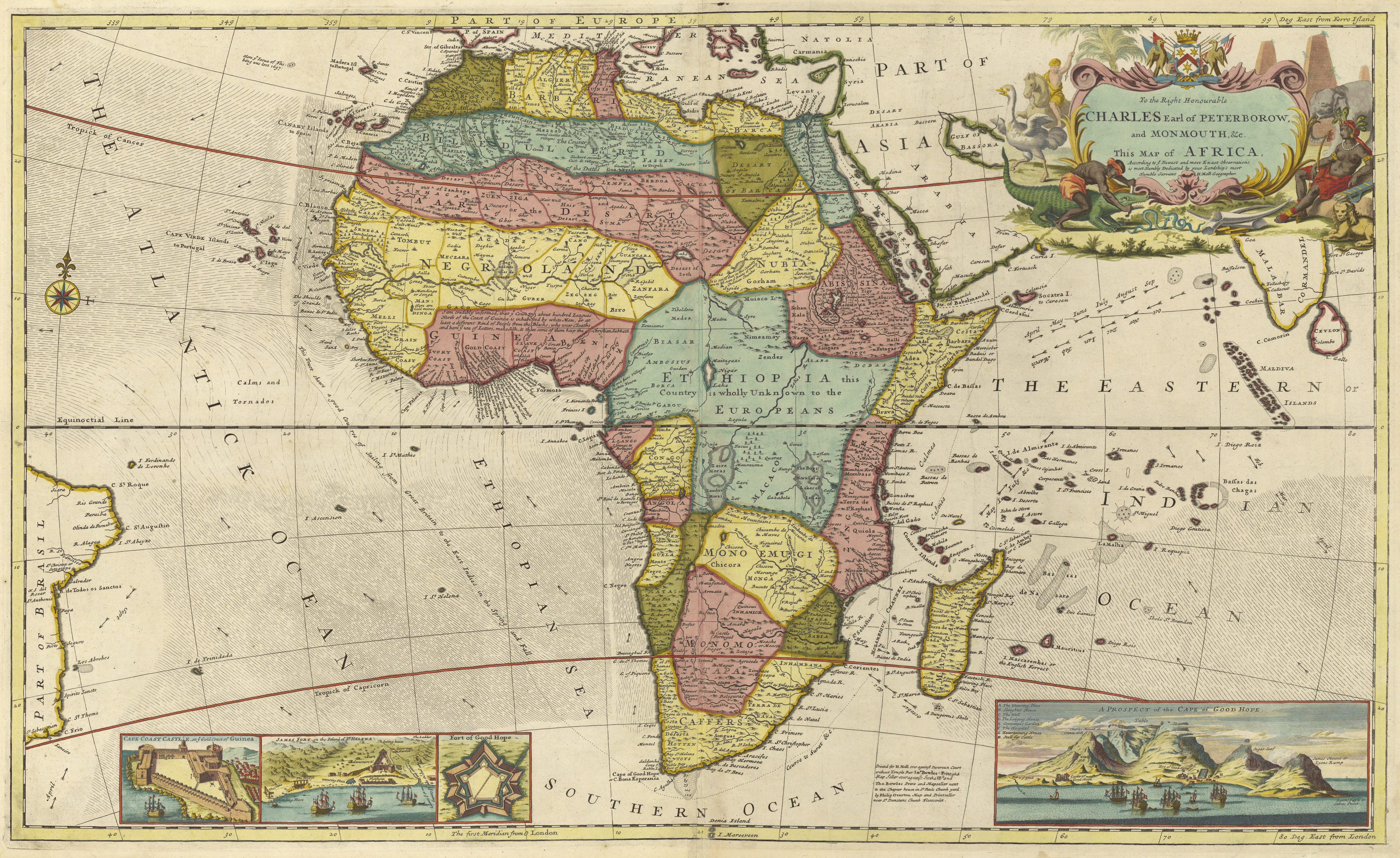
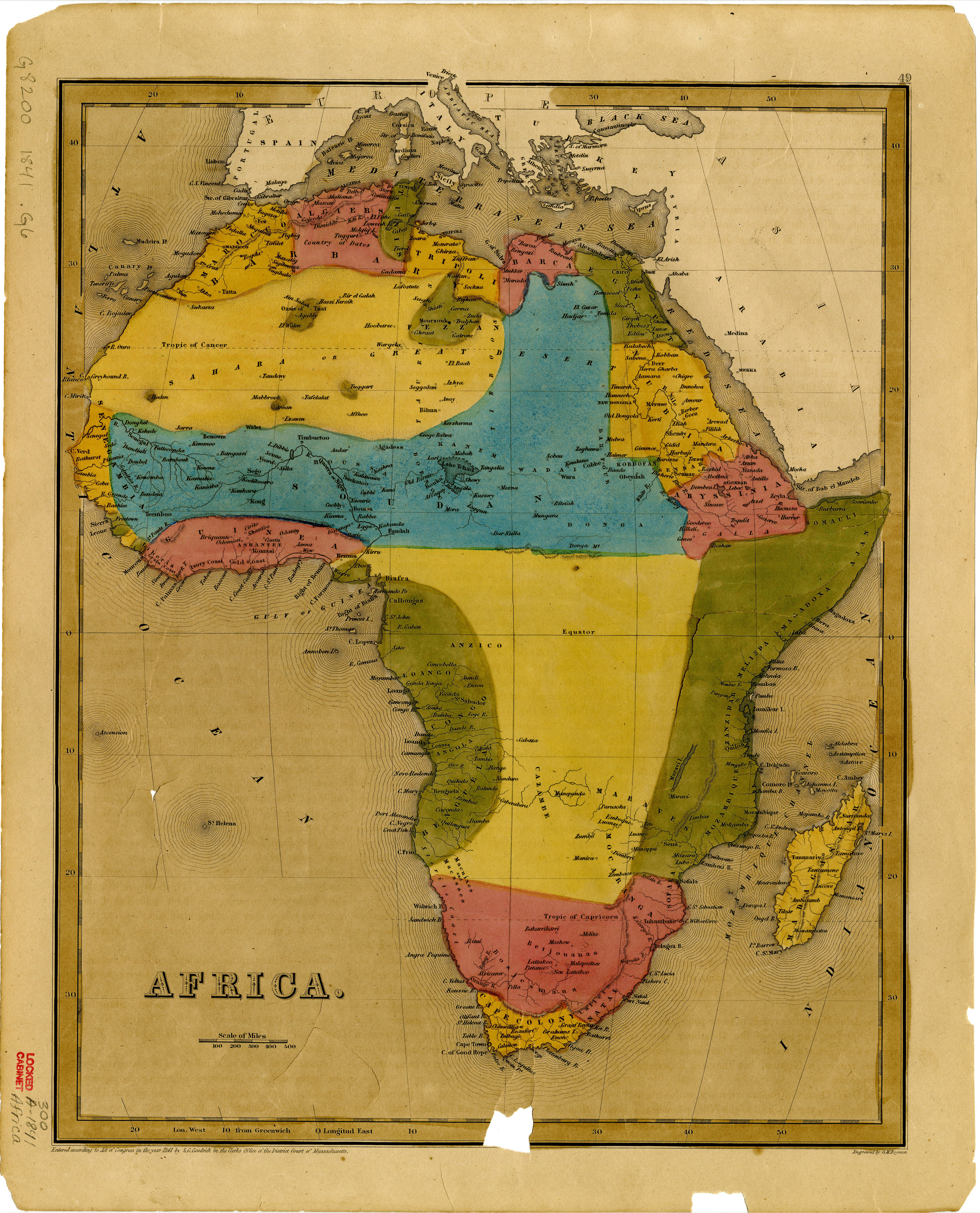
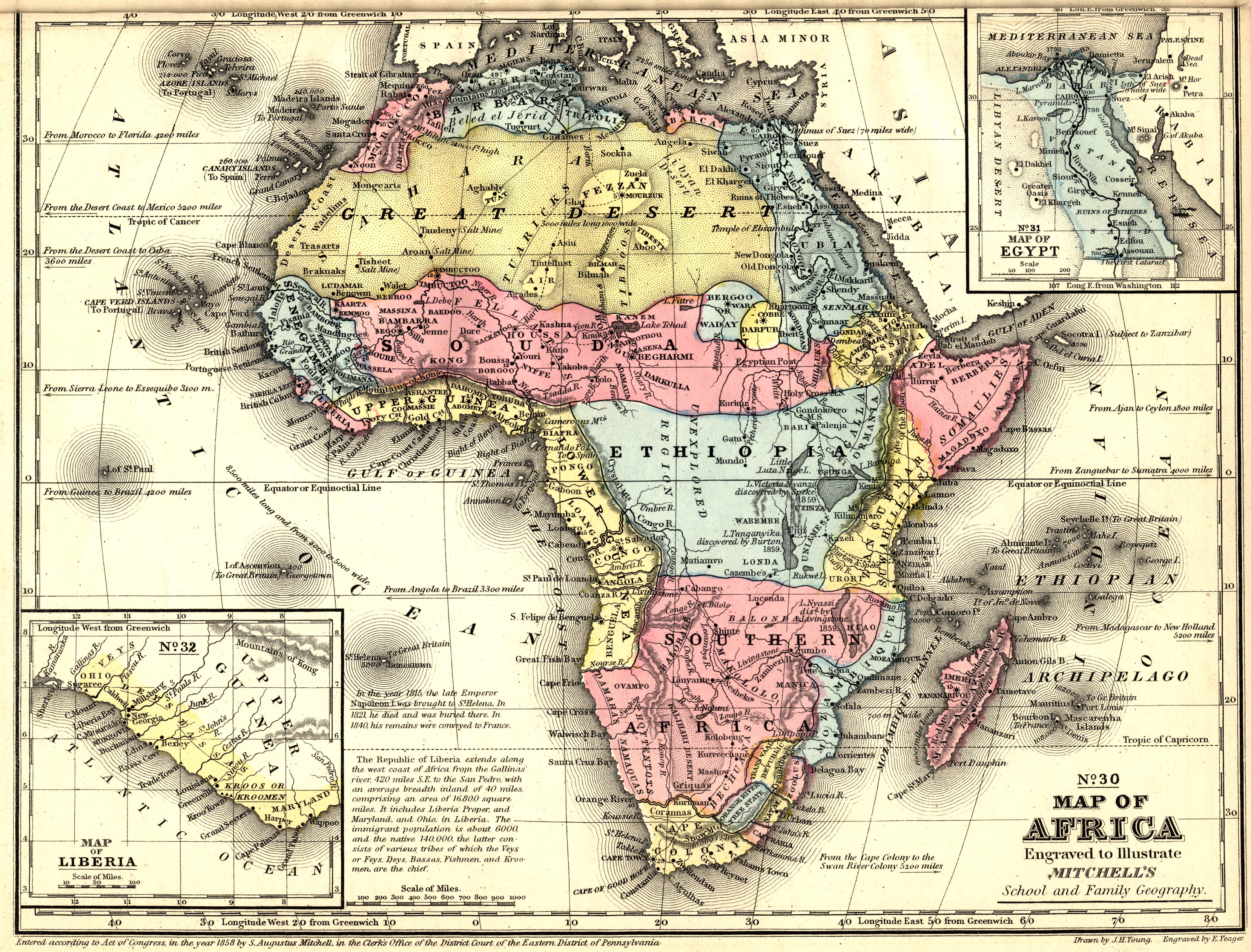
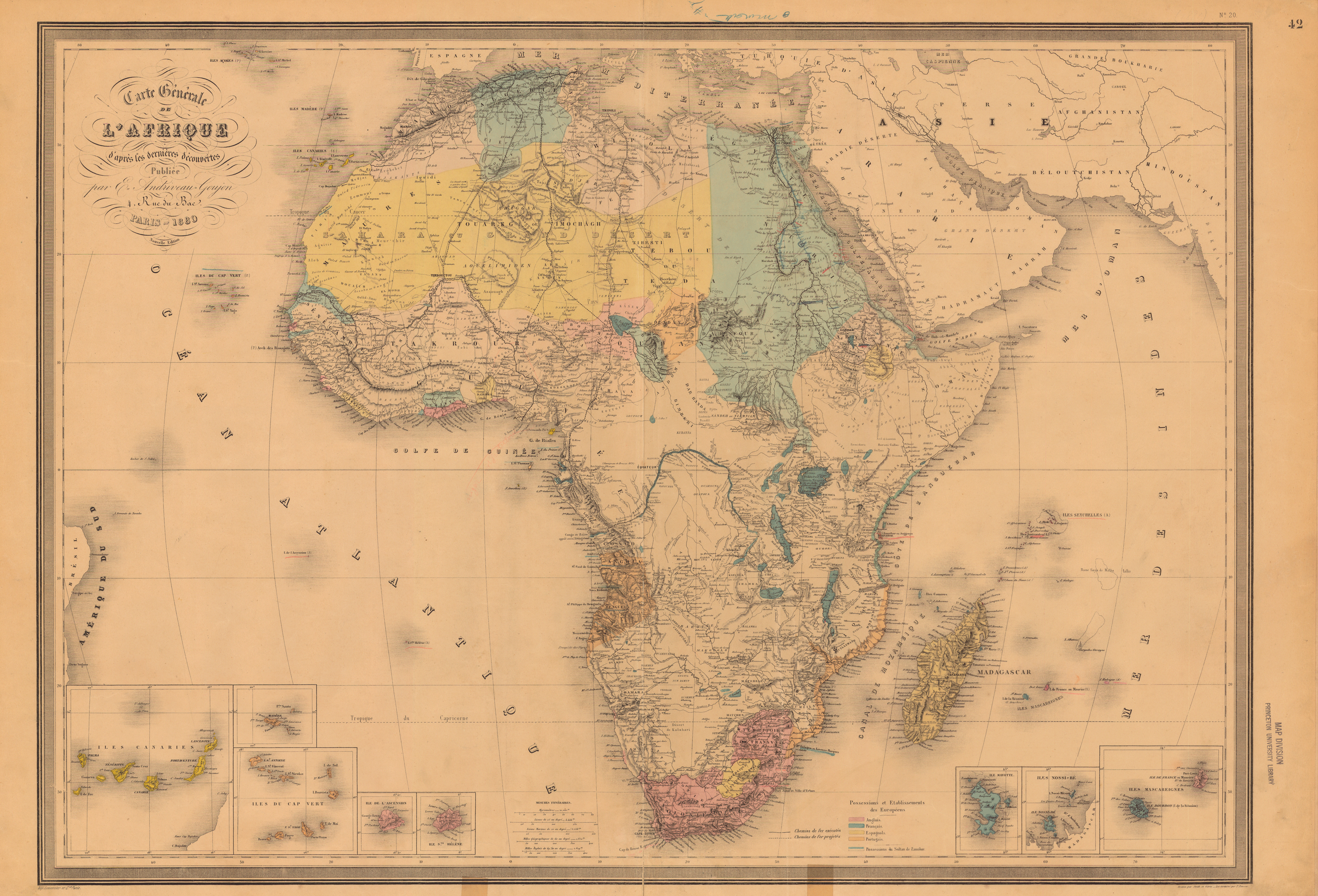
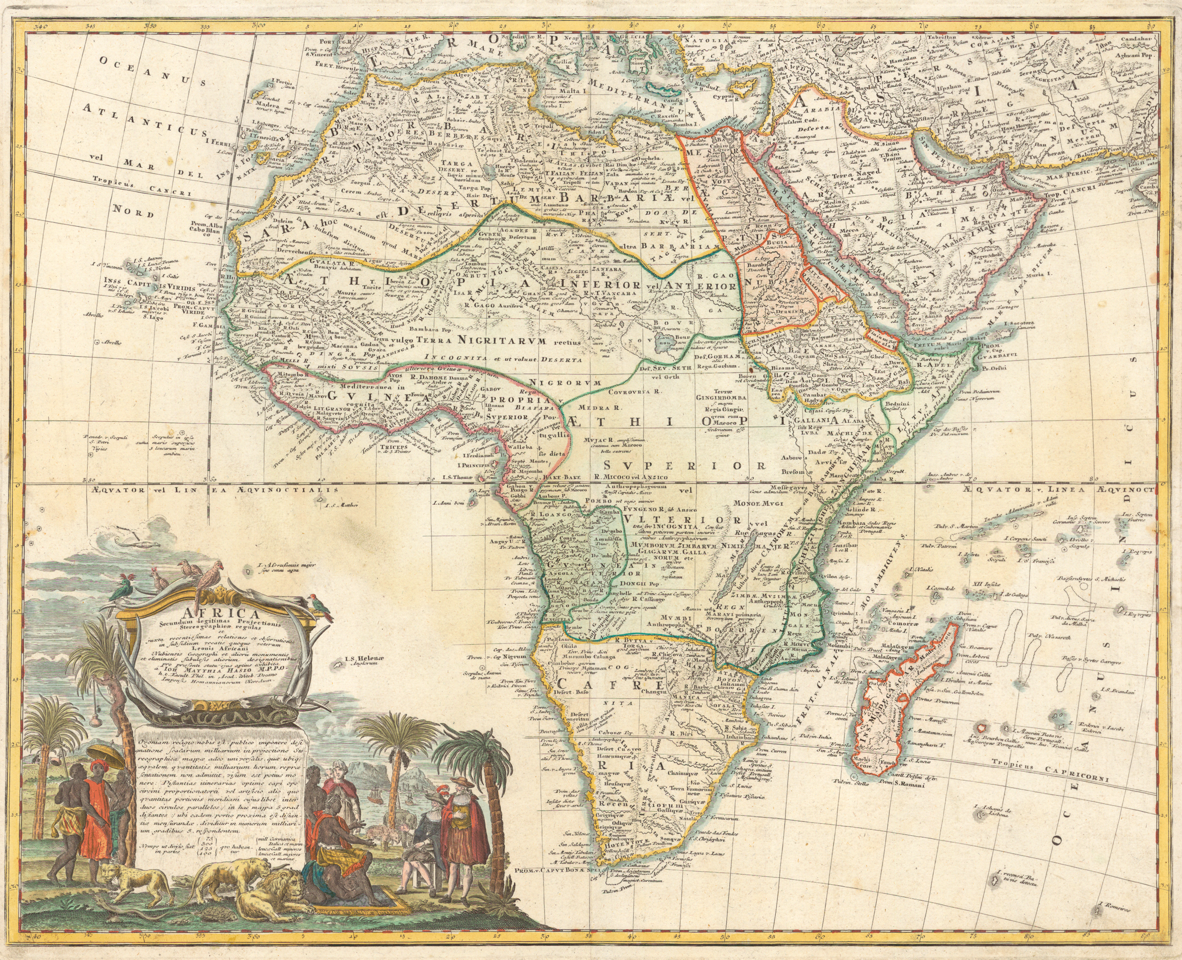
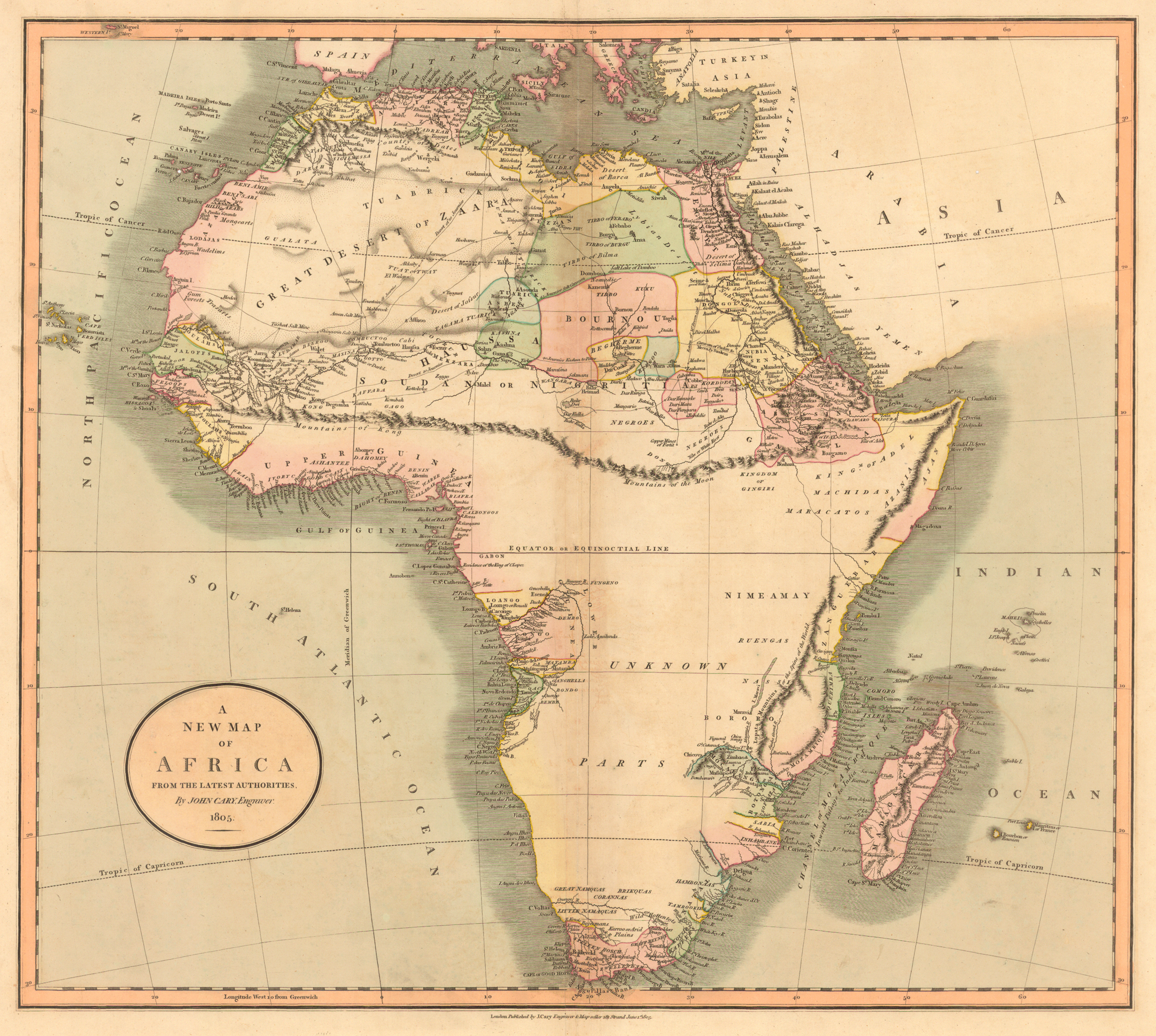
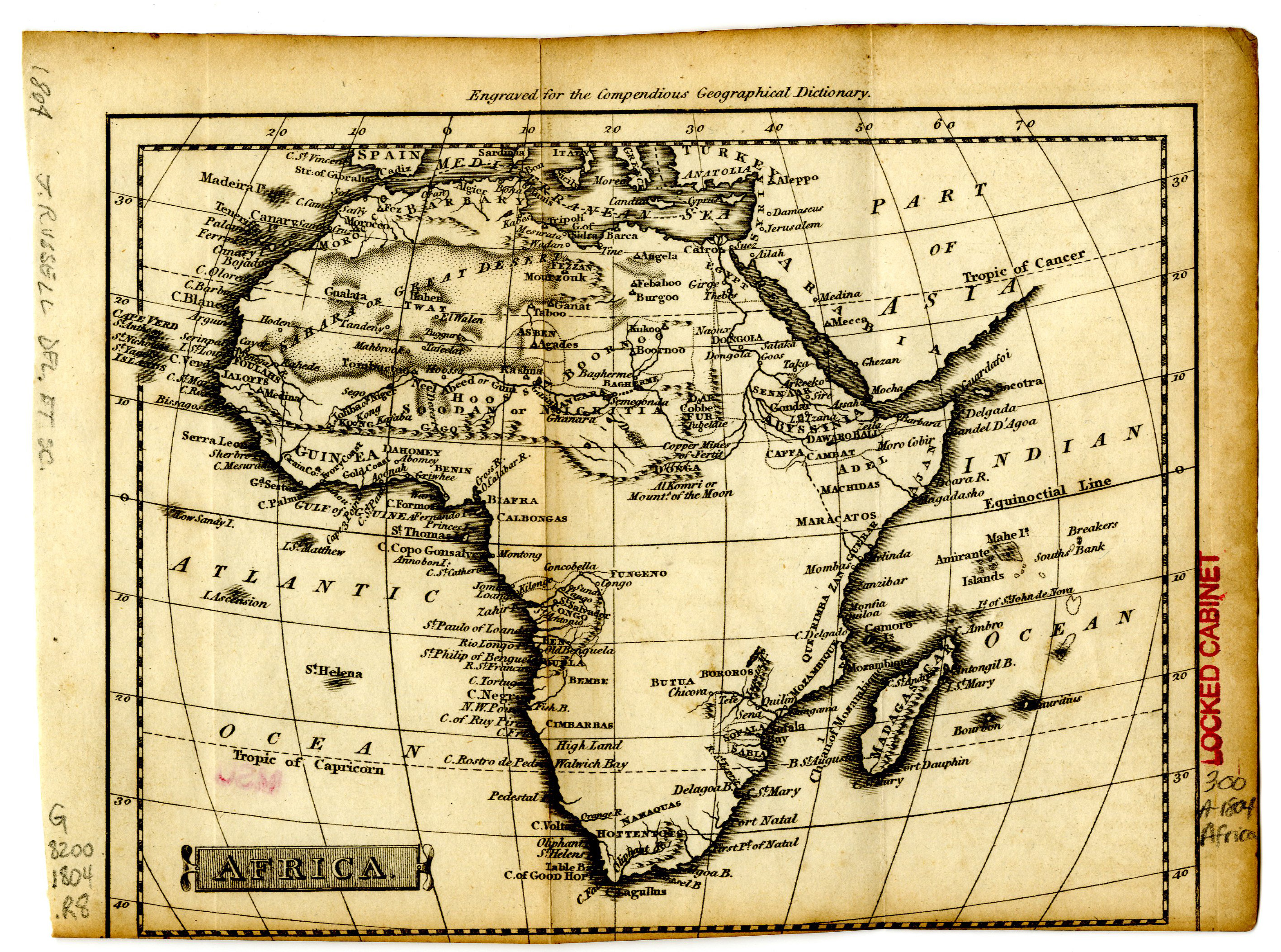
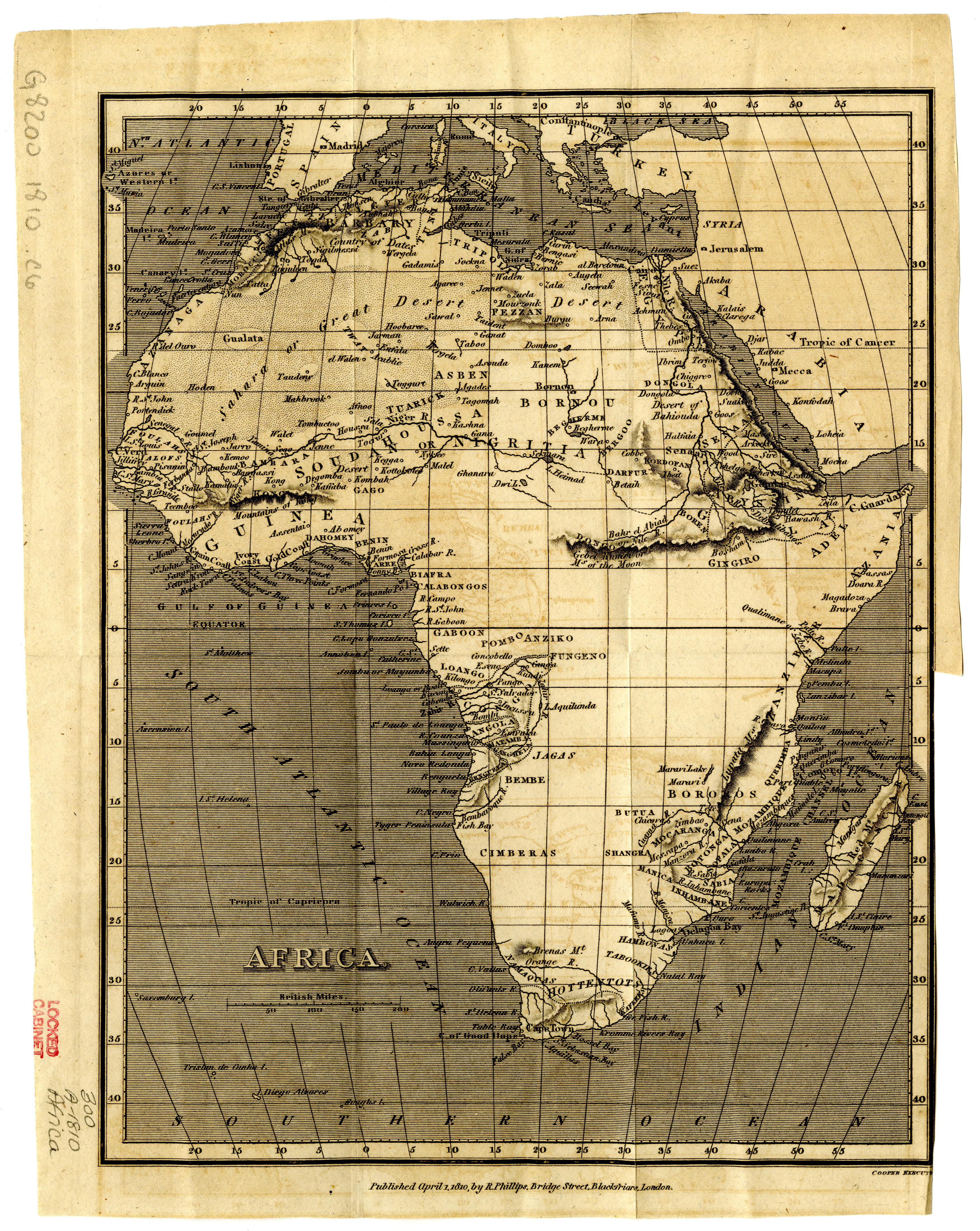
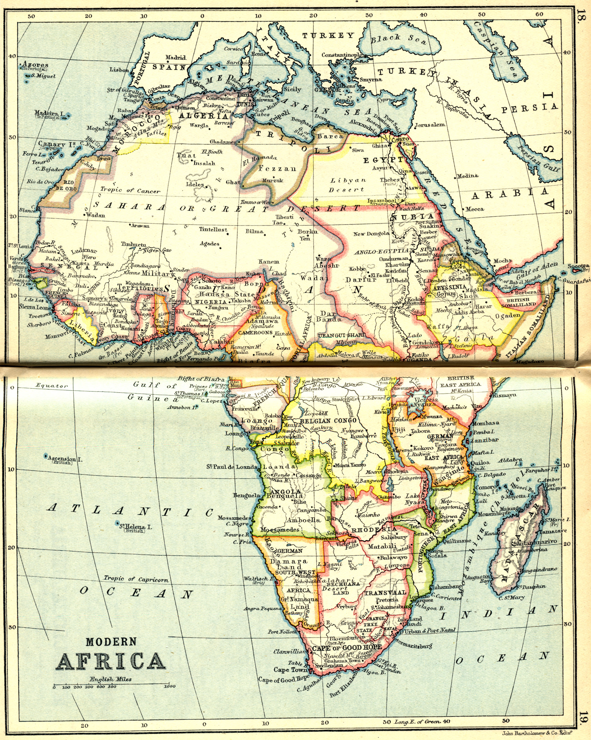
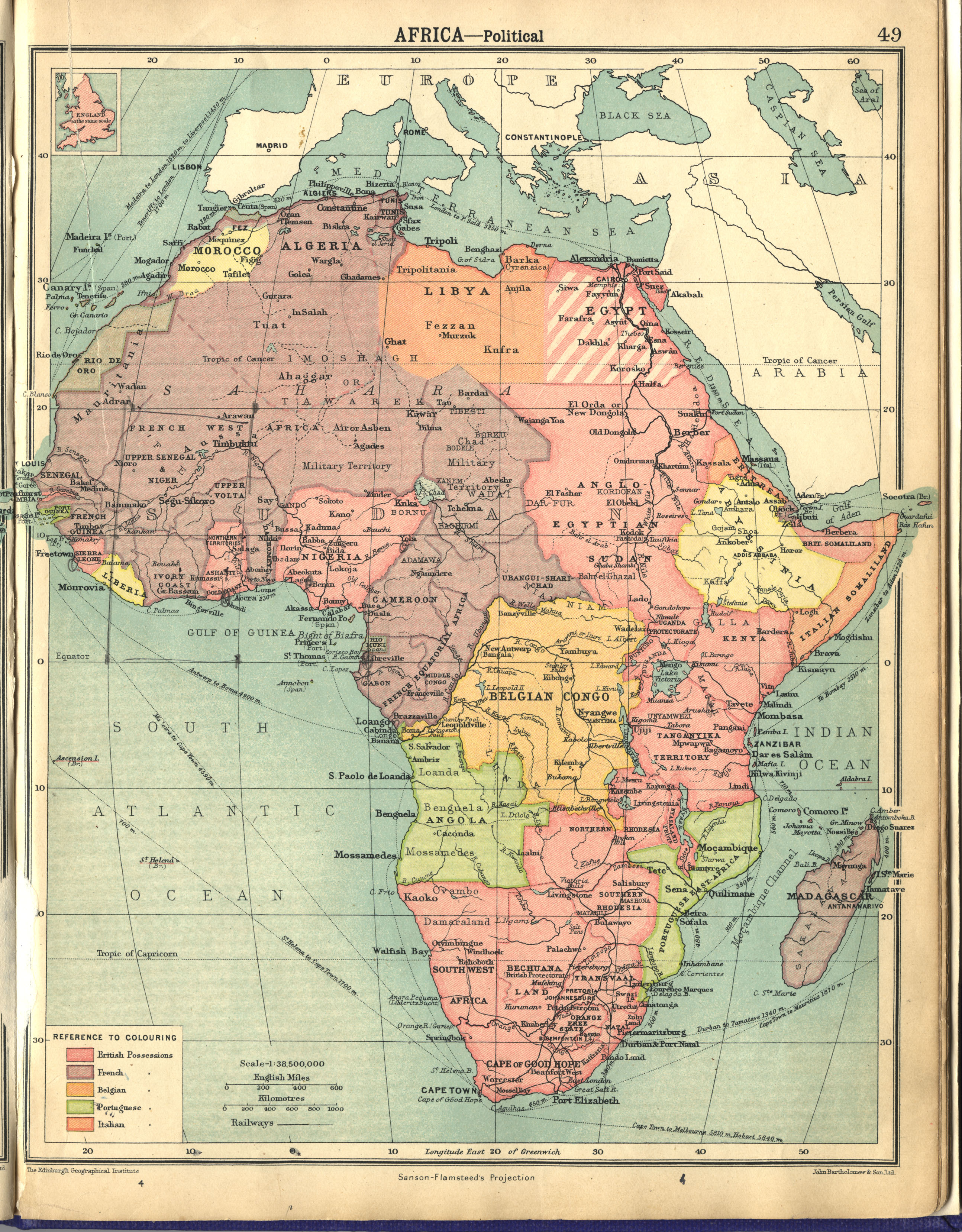
In contrast, United States of America started with a
union that was a true federation and has happily ever remained a united,
progressive and prosperous large country.
Who would not want to be part of a big and progressive
country in spite of being an autonomous unit? Who would not want to be part of
a big market economy and also benefit from other things of value derivable from
being part of a big and influential country? All the diverse ethnic
nationalities beamed in their real identities on a Federation screen would
surely present a kaleidoscopic beauty, all things being equal. I daresay that
what most people want is to be part of the kaleidoscopic beauty that is the
diverse but united, strong, equitable Federation, as autonomous federating
units.
This will mean
that any country in any of the federations still operating the troublesome
unitary government in any guise would consider immediate restructuring to true
federalism and not to leave it too late for hatred and mistrust to have time to
get unnecessarily ingrained into the psychic fabrics of citizens in conflict
areas, leading to an unfortunate, perennial dilemma.
The only persons who benefit from a unitary system of
government where wealth, power and authority are in one source, are the
self-centered and selfish, despotic, evil men who do not have the interest of
anybody at heart. Being very powerful, they easily position themselves at the
door of the store of the common wealth, help themselves to their fill and
manipulate the flow the way they please, which often sees wealth, power and
authority distributed in a provocatively inequitable manner, causing chaos and
conflicts in which environment they thrive in their art. True federalism
bye-passes such persons as wealth, power and authority thus reside in the units
on which The Center rather depends.
Those biting issues that make life difficult for
people in the unitary set up can be easily avoided if the Federations are
structured into true comprehensive federations where the federating units are
developing independently without being tied to the dependence on a Center, and
so are not affected by the demeanor of that Center, good or bad, towards any of
them; the Centre is significantly rendered unattractive, stemming the murderous
desires and moves to acquire and control power at the center and the attendant
serious consequences.
This is my vision for the real African countries that
will emerge through this retrieval process. The federations shall then become
real African countries – countries that are truly African - not some senseless European contraptions
foisted on Africa, with some entrenched colonial systems through which they
still remotely control African countries and some veiled neo-colonial
manipulations surreptitiously inserted into post-colonial cooperation
arrangements, which vary according to the colonial power but all having the
same aim of continued exploitation of Africa and continued protection of their
own interests - always.
While being careful of the neocolonial intrigues of
those past colonial powers, great vigilance is required so as not to fall
victim to an impeding new form of colonization coming from powers like China
and Russia (especially China) that pretend to be coming to the aid of Africans
as a supposedly much better alternative trading nation to the West, which
includes the past colonizers of Africa, and as disposed to be freely available
to aid Africa technologically and cooperate with African countries in cultural,
social and economic matters. They come looking super generous but begin to show
their true colors when they have taken hold of the country’s economy.
It is suggested that this retrieval process be
midwifed by the African Union in a serious Retrieval Conference, a sort of Counter Berlin Conference, which will
right the wrongs of that infamous conference, in a special way, putting the
suggestions in this work into consideration. This Africa Retrieval Conference – the “Counter Berlin Conference”, is
the launch and the take-off of the aforementioned grand revolution that will
enable those desired revolutions: political, economic, socio-cultural,
industrial, etc. After that, emerging real African countries shall work hard to
extricate themselves from vestiges of colonialism, position against
neocolonialism in any guise and maintain excellence in governance.
Smartness is not our problem in Africa but governance
based on the right template. Wrong governance template has been our bane in
addition to the European structural distortion of Africa.
Comprehensive
Federalism is the silver bullet that will surprisingly catapult the new Africa
towards quickly catching up with the so called first world and possibly
overtaking it as we already have the potential to do.
It is already showing in significant ways, along with
reversals that are taking place in multiple places. For instance, countless
first class African talents are already making serious waves all over the
world; Britain controlled her population by capitalizing on their privileged
advanced knowledge that availed advanced technology, to export her citizens all
over the world, colonizing them and continuing to manipulate them. They and
other advanced countries have continued to control their population, negatively
this time, through birth control. Now they have a serious dearth of qualified
young hands to run their economy having been family-planning themselves out of
existence in their “advanced” way of life and now have mostly aged people. They
are continually relying on our own human resource exports to their countries
for their work force. It is our turn to export and occupy.
Our main task at this moment, however, is to seriously
think of the retrieval of our continent. Launching into true economic,
political and cultural independence while maintaining good relations with all
countries, although careful of clever manipulative machinations, having
officially and genuinely forgiven the wrongs of the past, Africa shall have
retrieved peace, progress and prosperity. This will take away the present shame
from future generations in Africa.
Epilogue
Not highly schooled in history, in economics or in
politics, I may not have nearly given enough reasons, with the appropriate
technical arguments, why this call to retrieve Africa is dire. I have a sincere
feeling that if an impression has been made on you by this work, a much greater
favourable argument which is there, somewhere, waiting to be unleashed, can
give you a greater conviction. So is my feeling regarding the import of this
consideration mooted in this discourse that contains some fairly persuasive
logic: the need and the possibility of retrieving Africa from the quagmire in
which colonization has immersed her and from which she breathes no thought of
exiting. I hope this work has been able to, at least, draw attention to an
important issue.
This has been an interesting journey through
metamorphosis of ideas from a consequential evolution of thoughts, which has
now produced three books that have inevitably shared vital materials in their
development – maps, pictures, narratives – as already acknowledged in the
second book, Biafra Federation.
It all started from my observation of some daunting
anomalies in the structure and process of governance in Nigeria with resultant
conflicts, marginalization, agitations, suppressions and repressions in several
quarters. Prominent is the discomfort caused the authorities by the name
“Biafra” which they perceived to be a metaphor for secession without perceiving
why secession is becoming a possibility and why their actions and inactions are
fueling that possibility.
I
was distressed to see the mountain heap of ignorance, misinformation and
misunderstanding about Biafra and the jumping in of Nnamdi Kanu and his brand
of IPOB (Indigenous People of Biafra) brought great misconception and confusion
about what “Biafra” really stood for. I, therefore, had the urge to set the
records straight in most of the areas. For this, “Biafra Our Default Homeland”1
was born. The book set out to establish that “Biafra” was not a name we were
fighting to be allowed to acquire but a name that had been the name of a large
homeland that had included our Eastern part of
Nigeria since many centuries; it showed the extent of that homeland in
the present age. As explained in a part of the book, “As it is now, we are not asking to be allowed to
be called Biafrans because we are already Biafrans legitimately, naturally and
by default, by being citizens of a bona fide long-time homeland of ours called
Biafra. What we are asking for is for common sense to prevail and let Nigeria
be restructured into a true federation so that our Biafranness can find a
fertile ground to blossom effectually and maximally benefit Nigeria as a whole.
“We are Biafrans of
Nigeria. Our geo-political region is, specifically, West Biafra. It is like
naming the autonomous regions (states) in the USA, North Dakota, West Virginia,
North Carolina and South Carolina, and the reason some countries are known as
East Timor and South Sudan. All these names are full of history. I believe the
country we founded in 1967 and lost in 1970 should have been more correctly
named West Biafra as we share the Biafra name with three other countries -
Cameroon (Central Biafra), Gabon (South Biafra) and Equatorial Guinea
(Equatorial Biafra).
“We have a Nigerian
Identity and we cannot leave Nigeria for anybody, all things being equal,
conditions being conducive. No, not after working so hard in the building of
Nigeria and contributing more than other groups in the development of every
other part of Nigeria, for Biafrans are the ones that are found in every part
of Nigeria, including the remotest of parts, contributing magnificently and
selflessly to their host communities, and gaining much from them too. In other
words, Nigeria belongs to Biafrans because Biafra is the real name of the
geographical area called Eastern Nigeria or Eastern Region, which entered into
a true Federalism with other parts to form Nigeria.”
The book advocated restructuring Nigeria into a true federation, failure of which would make that feared possibility of secession become a reality, not only with “Biafra” but also with “Oodua” and other agitations. Failing to restructure to true federalism, a break-up of Nigeria would occur and in the event of that happening, we ought to think about joining other parts of Biafra homeland (Cameroon, Equatorial Guinea and Gabon) to form Biafra Federation, the book hinted. This thought gave birth to the book “Biafra Federation”3 which noted that European drawn borders balkanized the Biafra Kingdom of old and that that authentic indigenous African territory that was a peaceful kingdom should be retrieved into a modern Biafra Federation.
The
chapter in that book titled “Retrieval” starts with the following: “Present
African countries are artificial creations of the Europeans. Many of the
internal conflicts in most of these countries are as a result of the
incompatibilities of various parts joined together to form doomed amalgamations
called countries.” The thought that other African countries were in the same
situation gave rise to a metamorphosis to the greater thought of retrieving the
whole of Africa and gave birth to this book “Retrieve Africa”.
Here
we are, concluding these thoughts and believing that considerations for action
are to be elicited. The message is simple and seems complicated, with respect
to implementation possibilities and what strategies to adopt. When a knot seems
difficult to untie, you can only succeed to untie it by starting to untie it.
Three
anonymous proverbs written by Dr Leonie McSweeney, in her book “Facts of Life”,
are relevant here:
1.
You may be on the right way but you will get run over if you do not move
2.
I thought somebody should do something about this, then I realized I was
somebody
3. Trying when there is little chance of success is to risk failure but not to try at all is to guarantee failure.
We have the right to rue over our predicament but without moving on to at least thinking of a possibility of correction, we will only sink further, get worse and head to a kind of catastrophe, such as getting taken over by countries like China which is furtively moving to take over the economies of African countries, tricking them into attractive-looking but irredeemable loans each with a clause in the agreement that hands over the country’s economy to China for a default that was sure to happen. Some African countries have already reached this point and it is all due to bad economy from bad governance that had a lot to do with the bad structure left behind by Europeans.
Where are our activists? Are they disposed to thinking about a way out? No one is exempt from doing something about the situation. Begin to reshape narratives if you care. I have started doing my bit by putting these thoughts together. You can blog about it, you can write about it in an appropriate media. Let these thoughts go viral one way or the other. Chat with friends and neighbours about it. Our leaders are already tasked in this work – to get things accomplished through the suggested Retrieval Conference to counter the effects of the Berlin Conference that destroyed the indigenous African governance structure.
They patiently sat down in a conference of European countries that could not strictly be classified as very friendly with each other or usually cooperative with each other but usually regarded as competitors. They got their individual interests through a collective mutual agreement. African countries are in a better position, in this age with facilities for virtual meetings and continuous online discussions and decision-taking, to achieve a simple feat of restructuring, thereby retrieving Africa.
As has been said before, this matter is simple but looks complicated. The chance of success does not seem to be clearly foreseeable only because of the foreseeable difficulty of generating the political will for this in our African leaders. Political will is the key to the success of the project. But it is clearly true that, deciding to attempt untying a tough knot, a little educated pull somewhere may result in a sudden disentanglement and resolution and that trying when there is little chance of success is to risk failure but not to try at all is to guarantee it.
Not to try at all leaves us in a virtual comfort zone we now occupy and may not have the motivation to seek exit from. It leaves us with the justification of the prevailing and widely pervading harsh and demeaning perception that Africans are born to be in perpetual servitude, are cowards, have no sense of collective purpose, are greedy, have no interest in fighting or dying for anything, docile, lazy and stupid. This perception has been loudly expressed in every quarter and includes that they are easily given to thwarting their likes’ good-leadership efforts.
An example is that derisive remark about Negroes made
by Mehtma Mohammed, the 18th century Arab slave trader who sold hundreds of
Negroes into slavery. According to
Mehtma Mohammed:
“These black creatures were born to be in perpetual
servitude and were ordained by God to be our slaves forever. They are lazy, greedy, stupid, godless, dirty
and most important of all, they are cowards.
When you put the whip to them and line them up, they will do anything
for you. They and their African brothers
who sell them to us have no sense of collective purpose and they think nothing
of killing and selling their own kinsmen for a pittance.
“They have no
god and they have no interest in dying for or fighting for anything which is
outside their daily feeding. They are
docile, lazy, dirty and stupid and that is why I have made so much money from
selling them. The most gratifying thing
is that even if one of the groups shows signs of any potential or hope of being
able to be a great leader to the others, they are the ones that will expose
him, report him and destroy him just for a few morsels from my table.”16
If you think these words are revulsive, wait until you
hear a few more from a few more others. Femi Fani-Kayode described Mehtma
Mohammed’s remark as “painful and harsh words”. He goes on:
“Yet sadly such views about the African are not limited to the likes of him or
indeed to the 18th century. Permit me to give you just one example.
“The
following is a speech that was made by former South African President P.W.
Botha to his Cabinet. This reprint was written by David G. Mailu for the Sunday
Times, a South African newspaper, dated August 18, 1985. It reads as
follows:
“Pretoria
has been made by the White mind for the White man. We are not obliged even the
least to try to prove to anybody and to the Blacks that we are superior people.
We have demonstrated that to the Blacks in a thousand and one ways. The
Republic of South Africa that we know of today has not been created by wishful
thinking. We have created it at the expense of intelligence, sweat and blood.
Were they Afrikaners who tried to eliminate the Australian Aborigines? Are they
Afrikaners who discriminate against Blacks and call them Niggers in the States?
“Were
they Afrikaners who started the slave trade? Where is the Black man
appreciated? England discriminates against its Black and their “Sus” law is out
to discipline the Blacks. Canada, France, Russia, and Japan all play their
discrimination too…”17
The
rest of P. W. Botha’s speech contains many unprintable remarks that deeply
insult and sharply challenge Africans. There are many minds that easily tend to
agree with such assessments of Africans considering Africa’s economic and
technological backwardness and poor political development of African countries.
They tend to consider that Africa’s backwardness shows that Africans are less
intellectually endowed. However, performances of individual Africans wherever
they find themselves around the world prove the contrary.
There
must be a reason Africa is this backward while Africans are relatively very
smart. African governments do not have the right governance template for the
right development. Added to the contradictions caused by the European
distortions African countries are what they have consequently become. It
remains for us to, either agree with that derisive assessment as what we are,
do nothing and continue to be what we have become, or to prove the contrary by
considering the suggestions proffered herein if we have decided they are worth
considering. We now know what to do having seen that the answer lies in
retrieving Africa from that ugly place Europe had abandoned it and is still
furtively holding it down. Let the process begin and not delay anymore:
“Retrace the
natural boundaries of indigenous African nations or their pre-colonial
groupings and retrieve Africa from vestiges of colonialism and entrenched
neocolonialism, from entanglements in evitable perennial conflicts as a result
of the huge incompatibilities caused by artificial colonial creations and from
economic and political stranglehold, with resultant progress retardation.
Retrieve peace, progress and prosperity”.
References
1. Nweze C. C., Biafra
and Politics, Biafra Our Default Homeland, p100-101
2. Limba Mupetam, The Man Who Named Namibia - Mburumba
Kerina, The
Namibian. https://www.namibian.com.na/index.php?id=127811&page=archive-read
3. Nweze C. C., Retrieval, Biafra Federation, p45-49
4. Princeton University Library, 1644 map, Blaeu, Willem
Janszoon, 1571-1638. “Africae nova descriptio.” Copperpla te carte à figures map, with added
color, 35 x 45 cm., Evolution of the Map of Africa, https://lib dbserver.princeton.edu/visual_materials/maps/websites/africa/maps-continent/continent.html
5. Biafra Nations Youth League (BNYL), Bioko Igbos of Equatorial Guinea, a forgotten minority tribe, Facebook, August 26 2017.
6. Elizabeth Heath, Berlin Conference of 1884–1885, Oxford Reference,
http://www.oxfordreference.com/view/10.1093/acref/9780195337709.001.0001/acref-9780195337709-e-0467
7. DW, 130 Years Ago: Carving Up Africa in Berlin, https://www.dw.com/en/130-years-ago-carving-up-africa-in-berlin/a-18278894
8. Wikipedia, Southern Cameroons, https://en.wikipedia.org/wiki/Southern_Cameroons
9. Max Fisher, The Dividing of a Continent:
Africa's Separatist Problem, The Atlantic, September 12 2012. https://www.theatlantic.com/international/archive/2012/09/the-dividing-of-a-continent-africas-separatist-problem/262171/
10.
Reuters, Colonial Borders: Does Africa
Have a Choice? Africa News, reuters.com. http://blogs.reuters.com/africanews/2008/08/14/colonial-borders-does-africa-have-a-choice/
11.
Alesina A., Easterly W., and Matuszeski J., Artificial States,
Harvard University, New York University and Harvard University February 2006
Revised: May 2006 https://wcfia.harvard.edu/files/wcfia/files/alesina_artificialstates.pdf
12. The Guardian https://www.theguardian.com/world/2012/sep/06/kenya-ocean-coast-secessionist-party
13. Admin, The Scramble for Africa – The Berlin Conference. How Europeans Carved-Up Africa, Uncensored, Stories That Media Ignore, Novemder 18, 2018 https://uncensoredopinion.co.za/the-scramble-for-africa-the-berlin-conference/
14.
Wikipedia, Racism in Africa, https://en.wikipedia.org/wiki/Racism_in_Africa
15.
Nweze C. C., Center of the World
Biafra Federation page 72.
Comments
Post a Comment